You are here: Home > Network List > TA - USArray Transportable Network (new EarthScope stations) Stations List
> Station H18K Honhosa River, AK, USA > Earthquake Result Viewer
H18K Honhosa River, AK, USA - Earthquake Result Viewer
| Earthquake location: |
Solomon Islands |
| Earthquake latitude/longitude: |
-10.5/163.1 |
| Earthquake time(UTC): |
2018/11/16 (320) 03:26:55 GMT |
| Earthquake Depth: |
11 km |
| Earthquake Magnitude: |
6.2 mww |
| Earthquake Catalog/Contributor: |
NEIC PDE/us |
|
| Network: |
TA USArray Transportable Network (new EarthScope stations) |
| Station: |
H18K Honhosa River, AK, USA |
| Lat/Lon: |
65.15 N/158.36 W |
| Elevation: |
494 m |
|
| Distance: |
80.8 deg |
| Az: |
15.459 deg |
| Baz: |
218.342 deg |
| Ray Param: |
0.0480594 |
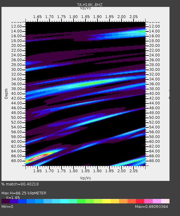
| Estimated Moho Depth: |
66.25 km |
| Estimated Crust Vp/Vs: |
1.65 |
| Assumed Crust Vp: |
6.1 km/s |
| Estimated Crust Vs: |
3.697 km/s |
| Estimated Crust Poisson's Ratio: |
0.21 |
|
| Radial Match: |
80.40218 % |
| Radial Bump: |
400 |
| Transverse Match: |
71.09566 % |
| Transverse Bump: |
400 |
| SOD ConfigId: |
13570011 |
| Insert Time: |
2019-05-01 20:19:04.371 +0000 |
| GWidth: |
2.5 |
| Max Bumps: |
400 |
| Tol: |
0.001 |
|

Signal To Noise
| Channel | StoN | STA | LTA |
| TA:H18K: :BHZ:20181116T03:38:37.749983Z | 8.713797 | 1.5680275E-6 | 1.7994769E-7 |
| TA:H18K: :BHN:20181116T03:38:37.749983Z | 3.1885643 | 4.909751E-7 | 1.5397998E-7 |
| TA:H18K: :BHE:20181116T03:38:37.749983Z | 2.2479496 | 4.4336582E-7 | 1.972312E-7 |
| Arrivals |
| Ps | 7.3 SECOND |
| PpPs | 28 SECOND |
| PsPs/PpSs | 35 SECOND |


