You are here: Home > Network List > TA - USArray Transportable Network (new EarthScope stations) Stations List
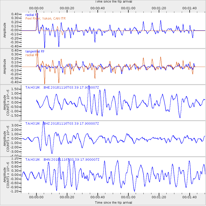
> Station H31M Peel River, Yukon, CAN > Earthquake Result Viewer
H31M Peel River, Yukon, CAN - Earthquake Result Viewer
| Earthquake location: |
Solomon Islands |
| Earthquake latitude/longitude: |
-10.5/163.1 |
| Earthquake time(UTC): |
2018/11/16 (320) 03:26:55 GMT |
| Earthquake Depth: |
11 km |
| Earthquake Magnitude: |
6.2 mww |
| Earthquake Catalog/Contributor: |
NEIC PDE/us |
|
| Network: |
TA USArray Transportable Network (new EarthScope stations) |
| Station: |
H31M Peel River, Yukon, CAN |
| Lat/Lon: |
65.81 N/134.34 W |
| Elevation: |
642 m |
|
| Distance: |
88.8 deg |
| Az: |
21.454 deg |
| Baz: |
240.776 deg |
| Ray Param: |
0.042342644 |
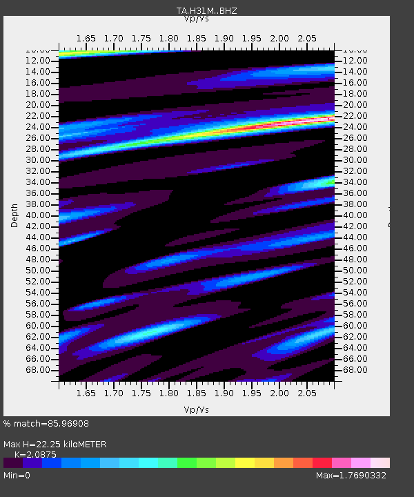
| Estimated Moho Depth: |
22.25 km |
| Estimated Crust Vp/Vs: |
2.09 |
| Assumed Crust Vp: |
6.419 km/s |
| Estimated Crust Vs: |
3.075 km/s |
| Estimated Crust Poisson's Ratio: |
0.35 |
|
| Radial Match: |
85.96908 % |
| Radial Bump: |
400 |
| Transverse Match: |
63.007496 % |
| Transverse Bump: |
400 |
| SOD ConfigId: |
13570011 |
| Insert Time: |
2019-05-01 20:19:10.512 +0000 |
| GWidth: |
2.5 |
| Max Bumps: |
400 |
| Tol: |
0.001 |
|
Signal To Noise
| Channel | StoN | STA | LTA |
| TA:H31M: :BHZ:20181116T03:39:17.900007Z | 10.914886 | 1.8654908E-6 | 1.7091253E-7 |
| TA:H31M: :BHN:20181116T03:39:17.900007Z | 0.90129185 | 2.138732E-7 | 2.3729626E-7 |
| TA:H31M: :BHE:20181116T03:39:17.900007Z | 1.8223736 | 7.855924E-7 | 4.31082E-7 |
| Arrivals |
| Ps | 3.8 SECOND |
| PpPs | 11 SECOND |
| PsPs/PpSs | 14 SECOND |


