You are here: Home > Network List > TA - USArray Transportable Network (new EarthScope stations) Stations List
> Station Q14A Sevier Lake (BLM), Delta, UT, USA > Earthquake Result Viewer
Q14A Sevier Lake (BLM), Delta, UT, USA - Earthquake Result Viewer
| Earthquake location: |
Southeast Of Loyalty Islands |
| Earthquake latitude/longitude: |
-21.2/169.4 |
| Earthquake time(UTC): |
2007/09/28 (271) 01:01:48 GMT |
| Earthquake Depth: |
10 km |
| Earthquake Magnitude: |
5.8 MB, 6.4 MS, 6.3 MW, 6.2 MW |
| Earthquake Catalog/Contributor: |
WHDF/NEIC |
|
| Network: |
TA USArray Transportable Network (new EarthScope stations) |
| Station: |
Q14A Sevier Lake (BLM), Delta, UT, USA |
| Lat/Lon: |
38.99 N/113.28 W |
| Elevation: |
1464 m |
|
| Distance: |
93.8 deg |
| Az: |
49.652 deg |
| Baz: |
245.854 deg |
| Ray Param: |
0.04118972 |
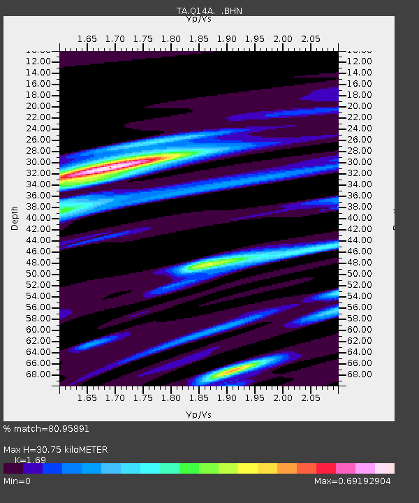
| Estimated Moho Depth: |
30.75 km |
| Estimated Crust Vp/Vs: |
1.69 |
| Assumed Crust Vp: |
6.276 km/s |
| Estimated Crust Vs: |
3.713 km/s |
| Estimated Crust Poisson's Ratio: |
0.23 |
|
| Radial Match: |
80.95891 % |
| Radial Bump: |
400 |
| Transverse Match: |
64.10364 % |
| Transverse Bump: |
393 |
| SOD ConfigId: |
2564 |
| Insert Time: |
2010-03-06 18:04:56.266 +0000 |
| GWidth: |
2.5 |
| Max Bumps: |
400 |
| Tol: |
0.001 |
|

Signal To Noise
| Channel | StoN | STA | LTA |
| TA:Q14A: :BHN:20070928T01:14:34.375024Z | 0.8216573 | 6.726029E-8 | 8.18593E-8 |
| TA:Q14A: :BHE:20070928T01:14:34.375024Z | 2.527432 | 1.6607959E-7 | 6.57108E-8 |
| TA:Q14A: :BHZ:20070928T01:14:34.375024Z | 4.0713477 | 3.6996835E-7 | 9.0871225E-8 |
| Arrivals |
| Ps | 3.4 SECOND |
| PpPs | 13 SECOND |
| PsPs/PpSs | 16 SECOND |


