You are here: Home > Network List > TA - USArray Transportable Network (new EarthScope stations) Stations List
> Station J18K Innoko River, AK, USA > Earthquake Result Viewer
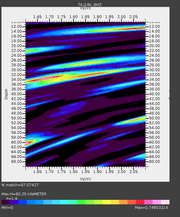
J18K Innoko River, AK, USA - Earthquake Result Viewer
| Earthquake location: |
Solomon Islands |
| Earthquake latitude/longitude: |
-10.5/163.1 |
| Earthquake time(UTC): |
2018/11/16 (320) 03:26:55 GMT |
| Earthquake Depth: |
11 km |
| Earthquake Magnitude: |
6.2 mww |
| Earthquake Catalog/Contributor: |
NEIC PDE/us |
|
| Network: |
TA USArray Transportable Network (new EarthScope stations) |
| Station: |
J18K Innoko River, AK, USA |
| Lat/Lon: |
63.47 N/156.72 W |
| Elevation: |
506 m |
|
| Distance: |
79.9 deg |
| Az: |
17.11 deg |
| Baz: |
220.103 deg |
| Ray Param: |
0.04864465 |
| Estimated Moho Depth: |
60.25 km |
| Estimated Crust Vp/Vs: |
1.60 |
| Assumed Crust Vp: |
6.182 km/s |
| Estimated Crust Vs: |
3.864 km/s |
| Estimated Crust Poisson's Ratio: |
0.18 |
|
| Radial Match: |
87.07427 % |
| Radial Bump: |
392 |
| Transverse Match: |
71.40275 % |
| Transverse Bump: |
400 |
| SOD ConfigId: |
13570011 |
| Insert Time: |
2019-05-01 20:19:20.079 +0000 |
| GWidth: |
2.5 |
| Max Bumps: |
400 |
| Tol: |
0.001 |
|

Signal To Noise
| Channel | StoN | STA | LTA |
| TA:J18K: :BHZ:20181116T03:38:33.124983Z | 6.1657524 | 1.7320016E-6 | 2.8090676E-7 |
| TA:J18K: :BHN:20181116T03:38:33.124983Z | 2.7202108 | 6.169041E-7 | 2.2678542E-7 |
| TA:J18K: :BHE:20181116T03:38:33.124983Z | 2.1457255 | 4.649925E-7 | 2.1670644E-7 |
| Arrivals |
| Ps | 6.0 SECOND |
| PpPs | 25 SECOND |
| PsPs/PpSs | 31 SECOND |


