You are here: Home > Network List > TA - USArray Transportable Network (new EarthScope stations) Stations List
> Station L27K Beaver Creek, Northway Junction, AK, USA > Earthquake Result Viewer
L27K Beaver Creek, Northway Junction, AK, USA - Earthquake Result Viewer
| Earthquake location: |
Solomon Islands |
| Earthquake latitude/longitude: |
-10.5/163.1 |
| Earthquake time(UTC): |
2018/11/16 (320) 03:26:55 GMT |
| Earthquake Depth: |
11 km |
| Earthquake Magnitude: |
6.2 mww |
| Earthquake Catalog/Contributor: |
NEIC PDE/us |
|
| Network: |
TA USArray Transportable Network (new EarthScope stations) |
| Station: |
L27K Beaver Creek, Northway Junction, AK, USA |
| Lat/Lon: |
63.06 N/141.83 W |
| Elevation: |
755 m |
|
| Distance: |
84.5 deg |
| Az: |
22.023 deg |
| Baz: |
234.062 deg |
| Ray Param: |
0.04540327 |
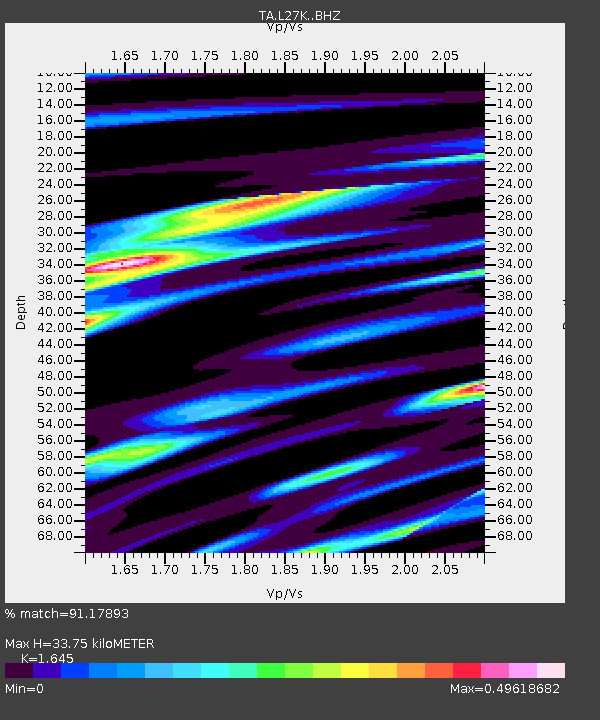
| Estimated Moho Depth: |
33.75 km |
| Estimated Crust Vp/Vs: |
1.64 |
| Assumed Crust Vp: |
6.566 km/s |
| Estimated Crust Vs: |
3.992 km/s |
| Estimated Crust Poisson's Ratio: |
0.21 |
|
| Radial Match: |
91.17893 % |
| Radial Bump: |
342 |
| Transverse Match: |
79.71653 % |
| Transverse Bump: |
365 |
| SOD ConfigId: |
13570011 |
| Insert Time: |
2019-05-01 20:19:37.056 +0000 |
| GWidth: |
2.5 |
| Max Bumps: |
400 |
| Tol: |
0.001 |
|
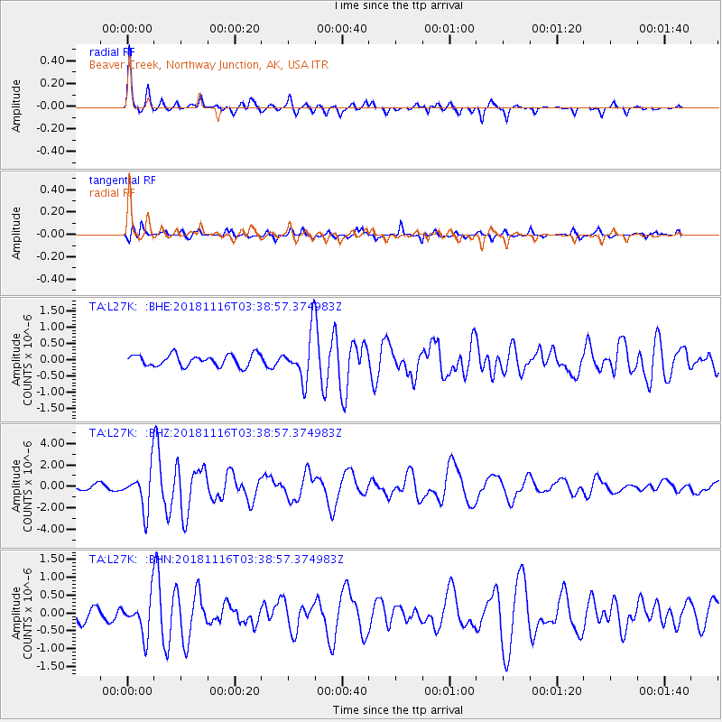
Signal To Noise
| Channel | StoN | STA | LTA |
| TA:L27K: :BHZ:20181116T03:38:57.374983Z | 9.69898 | 2.0004493E-6 | 2.0625356E-7 |
| TA:L27K: :BHN:20181116T03:38:57.374983Z | 2.5032623 | 5.6048435E-7 | 2.2390155E-7 |
| TA:L27K: :BHE:20181116T03:38:57.374983Z | 3.2884371 | 5.7568184E-7 | 1.7506244E-7 |
| Arrivals |
| Ps | 3.4 SECOND |
| PpPs | 13 SECOND |
| PsPs/PpSs | 17 SECOND |


