You are here: Home > Network List > TA - USArray Transportable Network (new EarthScope stations) Stations List
> Station Q14A Sevier Lake (BLM), Delta, UT, USA > Earthquake Result Viewer
Q14A Sevier Lake (BLM), Delta, UT, USA - Earthquake Result Viewer
| Earthquake location: |
Near Coast Of Peru |
| Earthquake latitude/longitude: |
-13.6/-76.6 |
| Earthquake time(UTC): |
2007/08/17 (229) 13:18:13 GMT |
| Earthquake Depth: |
48 km |
| Earthquake Magnitude: |
5.6 MB, 5.6 MS, 5.9 MW |
| Earthquake Catalog/Contributor: |
WHDF/NEIC |
|
| Network: |
TA USArray Transportable Network (new EarthScope stations) |
| Station: |
Q14A Sevier Lake (BLM), Delta, UT, USA |
| Lat/Lon: |
38.99 N/113.28 W |
| Elevation: |
1464 m |
|
| Distance: |
62.5 deg |
| Az: |
328.356 deg |
| Baz: |
139.115 deg |
| Ray Param: |
0.06006099 |
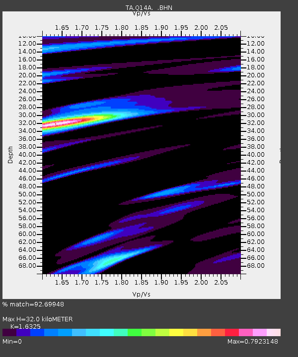
| Estimated Moho Depth: |
32.0 km |
| Estimated Crust Vp/Vs: |
1.63 |
| Assumed Crust Vp: |
6.276 km/s |
| Estimated Crust Vs: |
3.844 km/s |
| Estimated Crust Poisson's Ratio: |
0.20 |
|
| Radial Match: |
92.69948 % |
| Radial Bump: |
367 |
| Transverse Match: |
75.48332 % |
| Transverse Bump: |
400 |
| SOD ConfigId: |
2564 |
| Insert Time: |
2010-03-06 18:05:07.199 +0000 |
| GWidth: |
2.5 |
| Max Bumps: |
400 |
| Tol: |
0.001 |
|
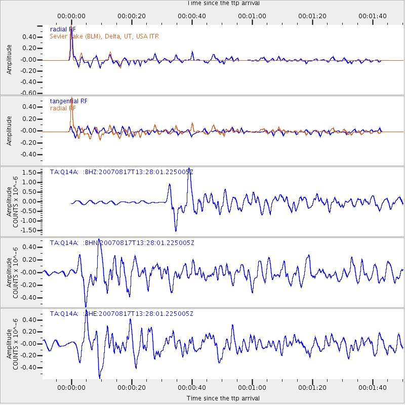
Signal To Noise
| Channel | StoN | STA | LTA |
| TA:Q14A: :BHN:20070817T13:28:01.225005Z | 6.273503 | 1.9078314E-7 | 3.0410945E-8 |
| TA:Q14A: :BHE:20070817T13:28:01.225005Z | 4.1311946 | 1.8532103E-7 | 4.4858943E-8 |
| TA:Q14A: :BHZ:20070817T13:28:01.225005Z | 9.931894 | 5.825971E-7 | 5.8659214E-8 |
| Arrivals |
| Ps | 3.4 SECOND |
| PpPs | 13 SECOND |
| PsPs/PpSs | 16 SECOND |


