You are here: Home > Network List > TA - USArray Transportable Network (new EarthScope stations) Stations List
> Station M16K Timber Creek, AK, USA > Earthquake Result Viewer
M16K Timber Creek, AK, USA - Earthquake Result Viewer

| Earthquake location: |
Solomon Islands |
| Earthquake latitude/longitude: |
-10.5/163.1 |
| Earthquake time(UTC): |
2018/11/16 (320) 03:26:55 GMT |
| Earthquake Depth: |
11 km |
| Earthquake Magnitude: |
6.2 mww |
| Earthquake Catalog/Contributor: |
NEIC PDE/us |
|
| Network: |
TA USArray Transportable Network (new EarthScope stations) |
| Station: |
M16K Timber Creek, AK, USA |
| Lat/Lon: |
61.02 N/158.96 W |
| Elevation: |
394 m |
|
| Distance: |
77.3 deg |
| Az: |
17.86 deg |
| Baz: |
218.267 deg |
| Ray Param: |
0.050392028 |
| Estimated Moho Depth: |
66.5 km |
| Estimated Crust Vp/Vs: |
2.08 |
| Assumed Crust Vp: |
6.276 km/s |
| Estimated Crust Vs: |
3.014 km/s |
| Estimated Crust Poisson's Ratio: |
0.35 |
|
| Radial Match: |
81.53518 % |
| Radial Bump: |
400 |
| Transverse Match: |
74.97548 % |
| Transverse Bump: |
400 |
| SOD ConfigId: |
13570011 |
| Insert Time: |
2019-05-01 20:19:42.121 +0000 |
| GWidth: |
2.5 |
| Max Bumps: |
400 |
| Tol: |
0.001 |
|
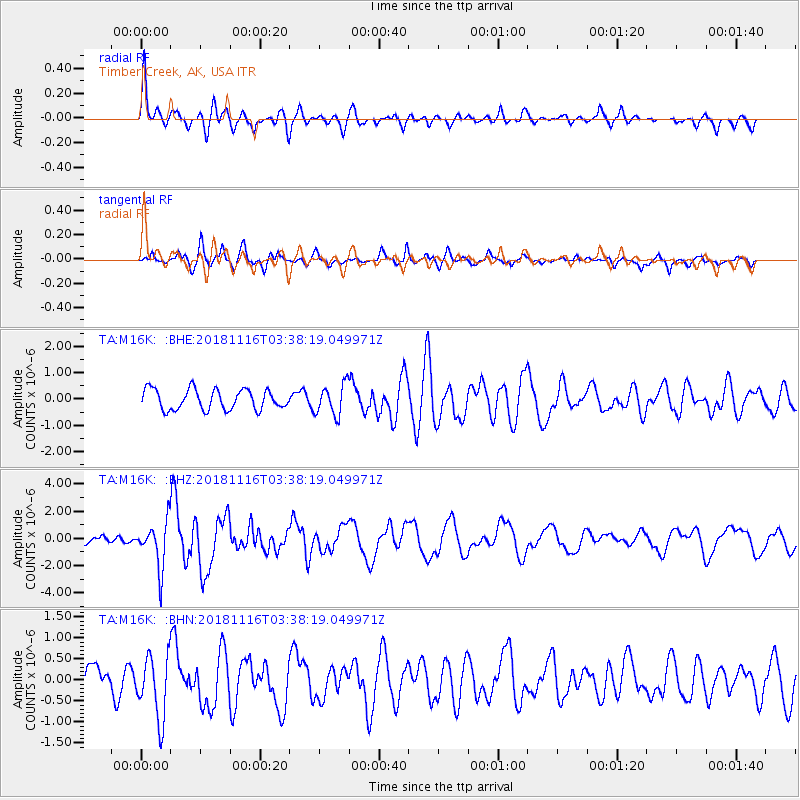
Signal To Noise
| Channel | StoN | STA | LTA |
| TA:M16K: :BHZ:20181116T03:38:19.049971Z | 5.499167 | 1.7152387E-6 | 3.1190882E-7 |
| TA:M16K: :BHN:20181116T03:38:19.049971Z | 2.4916227 | 7.547877E-7 | 3.029302E-7 |
| TA:M16K: :BHE:20181116T03:38:19.049971Z | 1.4246349 | 5.451007E-7 | 3.8262482E-7 |
| Arrivals |
| Ps | 12 SECOND |
| PpPs | 32 SECOND |
| PsPs/PpSs | 44 SECOND |


