You are here: Home > Network List > TA - USArray Transportable Network (new EarthScope stations) Stations List
> Station Q14A Sevier Lake (BLM), Delta, UT, USA > Earthquake Result Viewer
Q14A Sevier Lake (BLM), Delta, UT, USA - Earthquake Result Viewer

| Earthquake location: |
Andreanof Islands, Aleutian Is. |
| Earthquake latitude/longitude: |
50.2/-177.6 |
| Earthquake time(UTC): |
2007/08/16 (228) 04:03:03 GMT |
| Earthquake Depth: |
15 km |
| Earthquake Magnitude: |
5.8 MB |
| Earthquake Catalog/Contributor: |
WHDF/NEIC |
|
| Network: |
TA USArray Transportable Network (new EarthScope stations) |
| Station: |
Q14A Sevier Lake (BLM), Delta, UT, USA |
| Lat/Lon: |
38.99 N/113.28 W |
| Elevation: |
1464 m |
|
| Distance: |
45.8 deg |
| Az: |
78.478 deg |
| Baz: |
306.17 deg |
| Ray Param: |
0.07104222 |
| Estimated Moho Depth: |
69.75 km |
| Estimated Crust Vp/Vs: |
1.80 |
| Assumed Crust Vp: |
6.276 km/s |
| Estimated Crust Vs: |
3.496 km/s |
| Estimated Crust Poisson's Ratio: |
0.27 |
|
| Radial Match: |
85.13919 % |
| Radial Bump: |
346 |
| Transverse Match: |
52.47911 % |
| Transverse Bump: |
319 |
| SOD ConfigId: |
2564 |
| Insert Time: |
2010-03-06 18:05:11.818 +0000 |
| GWidth: |
2.5 |
| Max Bumps: |
400 |
| Tol: |
0.001 |
|
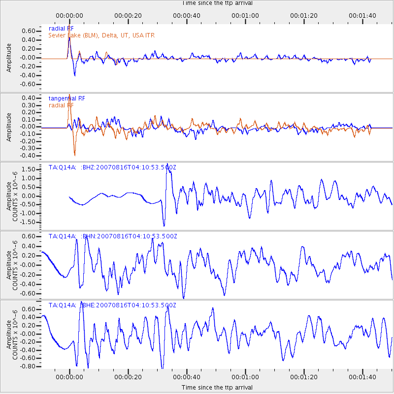
Signal To Noise
| Channel | StoN | STA | LTA |
| TA:Q14A: :BHN:20070816T04:10:53.500Z | 1.7361307 | 3.1259503E-7 | 1.8005271E-7 |
| TA:Q14A: :BHE:20070816T04:10:53.500Z | 2.3025231 | 5.3037536E-7 | 2.303453E-7 |
| TA:Q14A: :BHZ:20070816T04:10:53.500Z | 5.017115 | 1.0734093E-6 | 2.1394952E-7 |
| Arrivals |
| Ps | 9.4 SECOND |
| PpPs | 29 SECOND |
| PsPs/PpSs | 39 SECOND |


