You are here: Home > Network List > TA - USArray Transportable Network (new EarthScope stations) Stations List
> Station N30M Aishikik Lake, Yukon, CAN > Earthquake Result Viewer
N30M Aishikik Lake, Yukon, CAN - Earthquake Result Viewer
| Earthquake location: |
Solomon Islands |
| Earthquake latitude/longitude: |
-10.5/163.1 |
| Earthquake time(UTC): |
2018/11/16 (320) 03:26:55 GMT |
| Earthquake Depth: |
11 km |
| Earthquake Magnitude: |
6.2 mww |
| Earthquake Catalog/Contributor: |
NEIC PDE/us |
|
| Network: |
TA USArray Transportable Network (new EarthScope stations) |
| Station: |
N30M Aishikik Lake, Yukon, CAN |
| Lat/Lon: |
61.46 N/137.09 W |
| Elevation: |
941 m |
|
| Distance: |
85.5 deg |
| Az: |
24.601 deg |
| Baz: |
238.475 deg |
| Ray Param: |
0.044719487 |
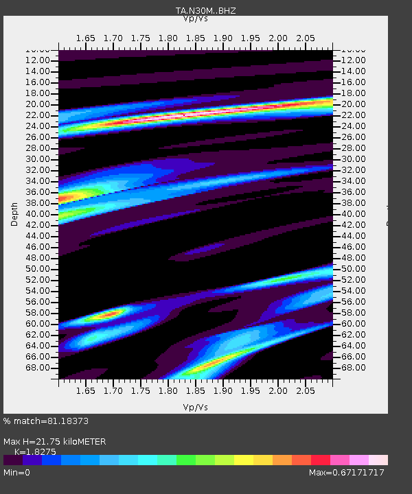
| Estimated Moho Depth: |
21.75 km |
| Estimated Crust Vp/Vs: |
1.83 |
| Assumed Crust Vp: |
6.566 km/s |
| Estimated Crust Vs: |
3.593 km/s |
| Estimated Crust Poisson's Ratio: |
0.29 |
|
| Radial Match: |
81.18373 % |
| Radial Bump: |
400 |
| Transverse Match: |
59.71444 % |
| Transverse Bump: |
400 |
| SOD ConfigId: |
13570011 |
| Insert Time: |
2019-05-01 20:19:56.901 +0000 |
| GWidth: |
2.5 |
| Max Bumps: |
400 |
| Tol: |
0.001 |
|

Signal To Noise
| Channel | StoN | STA | LTA |
| TA:N30M: :BHZ:20181116T03:39:02.124983Z | 5.9691515 | 1.5742606E-6 | 2.6373274E-7 |
| TA:N30M: :BHN:20181116T03:39:02.124983Z | 1.7924361 | 4.5519883E-7 | 2.539554E-7 |
| TA:N30M: :BHE:20181116T03:39:02.124983Z | 2.6552637 | 5.3261573E-7 | 2.0058866E-7 |
| Arrivals |
| Ps | 2.8 SECOND |
| PpPs | 9.1 SECOND |
| PsPs/PpSs | 12 SECOND |


