You are here: Home > Network List > TA - USArray Transportable Network (new EarthScope stations) Stations List
> Station O15K Ungalikthiuk River, AK, USA > Earthquake Result Viewer
O15K Ungalikthiuk River, AK, USA - Earthquake Result Viewer
| Earthquake location: |
Solomon Islands |
| Earthquake latitude/longitude: |
-10.5/163.1 |
| Earthquake time(UTC): |
2018/11/16 (320) 03:26:55 GMT |
| Earthquake Depth: |
11 km |
| Earthquake Magnitude: |
6.2 mww |
| Earthquake Catalog/Contributor: |
NEIC PDE/us |
|
| Network: |
TA USArray Transportable Network (new EarthScope stations) |
| Station: |
O15K Ungalikthiuk River, AK, USA |
| Lat/Lon: |
59.18 N/159.82 W |
| Elevation: |
306 m |
|
| Distance: |
75.6 deg |
| Az: |
18.68 deg |
| Baz: |
217.71 deg |
| Ray Param: |
0.05155338 |
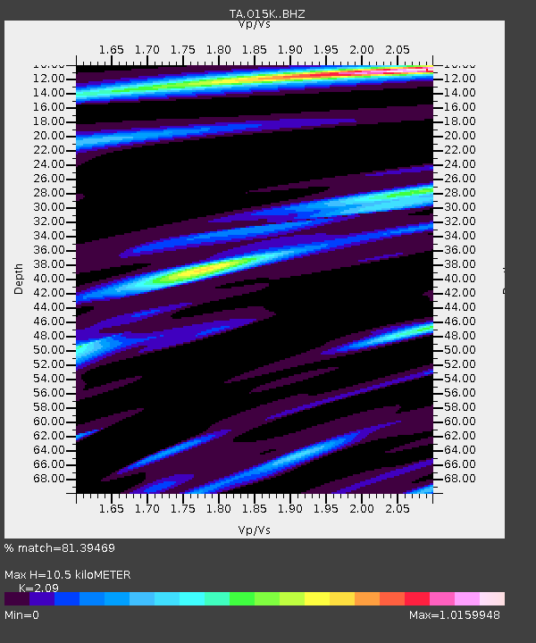
| Estimated Moho Depth: |
10.5 km |
| Estimated Crust Vp/Vs: |
2.09 |
| Assumed Crust Vp: |
6.24 km/s |
| Estimated Crust Vs: |
2.986 km/s |
| Estimated Crust Poisson's Ratio: |
0.35 |
|
| Radial Match: |
81.39469 % |
| Radial Bump: |
400 |
| Transverse Match: |
68.31741 % |
| Transverse Bump: |
400 |
| SOD ConfigId: |
13570011 |
| Insert Time: |
2019-05-01 20:19:59.004 +0000 |
| GWidth: |
2.5 |
| Max Bumps: |
400 |
| Tol: |
0.001 |
|

Signal To Noise
| Channel | StoN | STA | LTA |
| TA:O15K: :BHZ:20181116T03:38:09.299971Z | 6.615214 | 1.8502257E-6 | 2.796925E-7 |
| TA:O15K: :BHN:20181116T03:38:09.299971Z | 2.5703654 | 7.9613017E-7 | 3.0973425E-7 |
| TA:O15K: :BHE:20181116T03:38:09.299971Z | 1.7376558 | 4.7293216E-7 | 2.7216677E-7 |
| Arrivals |
| Ps | 1.9 SECOND |
| PpPs | 5.1 SECOND |
| PsPs/PpSs | 6.9 SECOND |


