You are here: Home > Network List > TA - USArray Transportable Network (new EarthScope stations) Stations List
> Station V35K Ketchikan, AK, USA > Earthquake Result Viewer
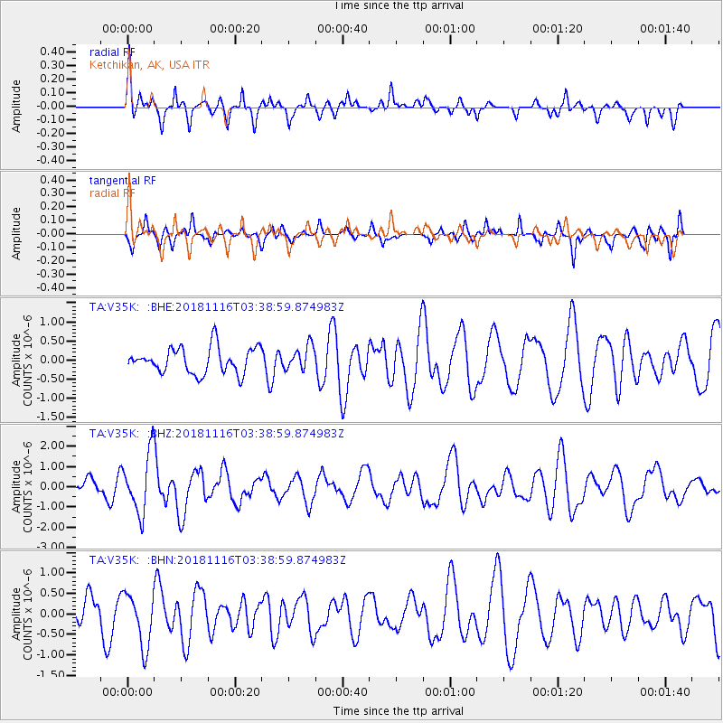
V35K Ketchikan, AK, USA - Earthquake Result Viewer
*The percent match for this event was below the threshold and hence no stack was calculated.
| Earthquake location: |
Solomon Islands |
| Earthquake latitude/longitude: |
-10.5/163.1 |
| Earthquake time(UTC): |
2018/11/16 (320) 03:26:55 GMT |
| Earthquake Depth: |
11 km |
| Earthquake Magnitude: |
6.2 mww |
| Earthquake Catalog/Contributor: |
NEIC PDE/us |
|
| Network: |
TA USArray Transportable Network (new EarthScope stations) |
| Station: |
V35K Ketchikan, AK, USA |
| Lat/Lon: |
55.33 N/131.62 W |
| Elevation: |
64 m |
|
| Distance: |
85.1 deg |
| Az: |
31.396 deg |
| Baz: |
243.696 deg |
| Ray Param: |
$rayparam |
*The percent match for this event was below the threshold and hence was not used in the summary stack. |
|
| Radial Match: |
58.63896 % |
| Radial Bump: |
290 |
| Transverse Match: |
61.9527 % |
| Transverse Bump: |
322 |
| SOD ConfigId: |
13570011 |
| Insert Time: |
2019-05-01 20:20:29.441 +0000 |
| GWidth: |
2.5 |
| Max Bumps: |
400 |
| Tol: |
0.001 |
|
Signal To Noise
| Channel | StoN | STA | LTA |
| TA:V35K: :BHZ:20181116T03:38:59.874983Z | 3.5402896 | 1.4931849E-6 | 4.217691E-7 |
| TA:V35K: :BHN:20181116T03:38:59.874983Z | 1.0623362 | 6.4848996E-7 | 6.104376E-7 |
| TA:V35K: :BHE:20181116T03:38:59.874983Z | 0.91459316 | 3.0775124E-7 | 3.3648976E-7 |
| Arrivals |
| Ps | |
| PpPs | |
| PsPs/PpSs | |


