You are here: Home > Network List > TA - USArray Transportable Network (new EarthScope stations) Stations List
> Station Q14A Sevier Lake (BLM), Delta, UT, USA > Earthquake Result Viewer
Q14A Sevier Lake (BLM), Delta, UT, USA - Earthquake Result Viewer

| Earthquake location: |
Vanuatu Islands |
| Earthquake latitude/longitude: |
-15.4/168.6 |
| Earthquake time(UTC): |
2007/07/15 (196) 09:27:34 GMT |
| Earthquake Depth: |
8.0 km |
| Earthquake Magnitude: |
6.0 MB, 5.8 MS, 6.1 MW, 6.0 MW |
| Earthquake Catalog/Contributor: |
WHDF/NEIC |
|
| Network: |
TA USArray Transportable Network (new EarthScope stations) |
| Station: |
Q14A Sevier Lake (BLM), Delta, UT, USA |
| Lat/Lon: |
38.99 N/113.28 W |
| Elevation: |
1464 m |
|
| Distance: |
90.6 deg |
| Az: |
49.703 deg |
| Baz: |
250.741 deg |
| Ray Param: |
0.04166202 |
| Estimated Moho Depth: |
68.0 km |
| Estimated Crust Vp/Vs: |
1.87 |
| Assumed Crust Vp: |
6.276 km/s |
| Estimated Crust Vs: |
3.352 km/s |
| Estimated Crust Poisson's Ratio: |
0.30 |
|
| Radial Match: |
94.4898 % |
| Radial Bump: |
385 |
| Transverse Match: |
89.838165 % |
| Transverse Bump: |
400 |
| SOD ConfigId: |
2564 |
| Insert Time: |
2010-03-06 18:05:33.484 +0000 |
| GWidth: |
2.5 |
| Max Bumps: |
400 |
| Tol: |
0.001 |
|
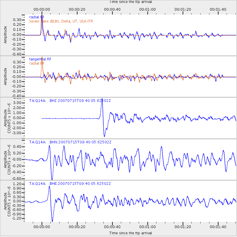
Signal To Noise
| Channel | StoN | STA | LTA |
| TA:Q14A: :BHN:20070715T09:40:05.62502Z | 5.611479 | 1.7051552E-7 | 3.038691E-8 |
| TA:Q14A: :BHE:20070715T09:40:05.62502Z | 14.812457 | 4.1320922E-7 | 2.789606E-8 |
| TA:Q14A: :BHZ:20070715T09:40:05.62502Z | 46.70682 | 1.3786579E-6 | 2.951727E-8 |
| Arrivals |
| Ps | 9.6 SECOND |
| PpPs | 31 SECOND |
| PsPs/PpSs | 40 SECOND |


