You are here: Home > Network List > TA - USArray Transportable Network (new EarthScope stations) Stations List
> Station Q14A Sevier Lake (BLM), Delta, UT, USA > Earthquake Result Viewer
Q14A Sevier Lake (BLM), Delta, UT, USA - Earthquake Result Viewer
| Earthquake location: |
Loyalty Islands |
| Earthquake latitude/longitude: |
-20.1/168.9 |
| Earthquake time(UTC): |
2008/04/09 (100) 12:46:12 GMT |
| Earthquake Depth: |
33 km |
| Earthquake Magnitude: |
6.3 MB, 7.3 MS, 7.3 MW, 7.3 MW |
| Earthquake Catalog/Contributor: |
WHDF/NEIC |
|
| Network: |
TA USArray Transportable Network (new EarthScope stations) |
| Station: |
Q14A Sevier Lake (BLM), Delta, UT, USA |
| Lat/Lon: |
38.99 N/113.28 W |
| Elevation: |
1464 m |
|
| Distance: |
93.4 deg |
| Az: |
49.744 deg |
| Baz: |
247.0 deg |
| Ray Param: |
0.041256897 |
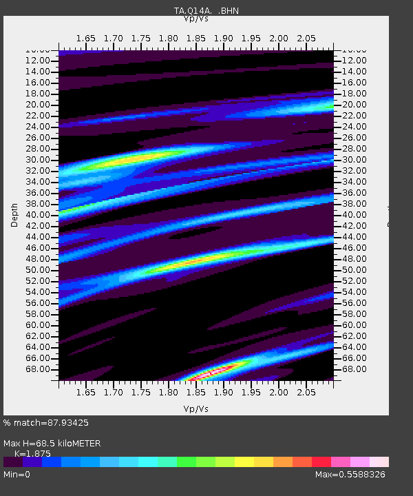
| Estimated Moho Depth: |
68.5 km |
| Estimated Crust Vp/Vs: |
1.88 |
| Assumed Crust Vp: |
6.276 km/s |
| Estimated Crust Vs: |
3.347 km/s |
| Estimated Crust Poisson's Ratio: |
0.30 |
|
| Radial Match: |
87.93425 % |
| Radial Bump: |
213 |
| Transverse Match: |
83.58762 % |
| Transverse Bump: |
400 |
| SOD ConfigId: |
2504 |
| Insert Time: |
2010-03-06 18:05:43.397 +0000 |
| GWidth: |
2.5 |
| Max Bumps: |
400 |
| Tol: |
0.001 |
|

Signal To Noise
| Channel | StoN | STA | LTA |
| TA:Q14A: :BHN:20080409T12:58:53.274016Z | 3.4226143 | 1.0154791E-6 | 2.9669692E-7 |
| TA:Q14A: :BHE:20080409T12:58:53.274016Z | 0.38935408 | 6.154995E-8 | 1.5808219E-7 |
| TA:Q14A: :BHZ:20080409T12:58:53.274016Z | 0.64341086 | 2.7745324E-7 | 4.3122247E-7 |
| Arrivals |
| Ps | 9.7 SECOND |
| PpPs | 31 SECOND |
| PsPs/PpSs | 41 SECOND |


