You are here: Home > Network List > TA - USArray Transportable Network (new EarthScope stations) Stations List
> Station Q14A Sevier Lake (BLM), Delta, UT, USA > Earthquake Result Viewer
Q14A Sevier Lake (BLM), Delta, UT, USA - Earthquake Result Viewer

| Earthquake location: |
South Of Mariana Islands |
| Earthquake latitude/longitude: |
12.5/143.2 |
| Earthquake time(UTC): |
2008/05/09 (130) 21:51:29 GMT |
| Earthquake Depth: |
76 km |
| Earthquake Magnitude: |
6.1 MB, 6.7 MW, 6.7 MW |
| Earthquake Catalog/Contributor: |
WHDF/NEIC |
|
| Network: |
TA USArray Transportable Network (new EarthScope stations) |
| Station: |
Q14A Sevier Lake (BLM), Delta, UT, USA |
| Lat/Lon: |
38.99 N/113.28 W |
| Elevation: |
1464 m |
|
| Distance: |
92.5 deg |
| Az: |
49.322 deg |
| Baz: |
288.143 deg |
| Ray Param: |
0.041411858 |
| Estimated Moho Depth: |
68.5 km |
| Estimated Crust Vp/Vs: |
1.89 |
| Assumed Crust Vp: |
6.276 km/s |
| Estimated Crust Vs: |
3.316 km/s |
| Estimated Crust Poisson's Ratio: |
0.31 |
|
| Radial Match: |
88.44225 % |
| Radial Bump: |
400 |
| Transverse Match: |
66.81756 % |
| Transverse Bump: |
400 |
| SOD ConfigId: |
2504 |
| Insert Time: |
2010-03-06 18:05:50.814 +0000 |
| GWidth: |
2.5 |
| Max Bumps: |
400 |
| Tol: |
0.001 |
|
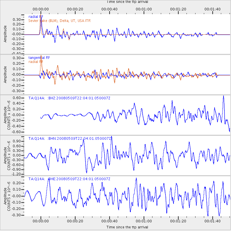
Signal To Noise
| Channel | StoN | STA | LTA |
| TA:Q14A: :BHN:20080509T22:04:01.050007Z | 4.6938343 | 3.841391E-7 | 8.183908E-8 |
| TA:Q14A: :BHE:20080509T22:04:01.050007Z | 2.0511072 | 1.3546E-7 | 6.604238E-8 |
| TA:Q14A: :BHZ:20080509T22:04:01.050007Z | 2.4310973 | 1.0247355E-7 | 4.2151154E-8 |
| Arrivals |
| Ps | 9.9 SECOND |
| PpPs | 31 SECOND |
| PsPs/PpSs | 41 SECOND |


