You are here: Home > Network List > UW - Pacific Northwest Regional Seismic Network Stations List
> Station YACT Amboy, WA, USA > Earthquake Result Viewer
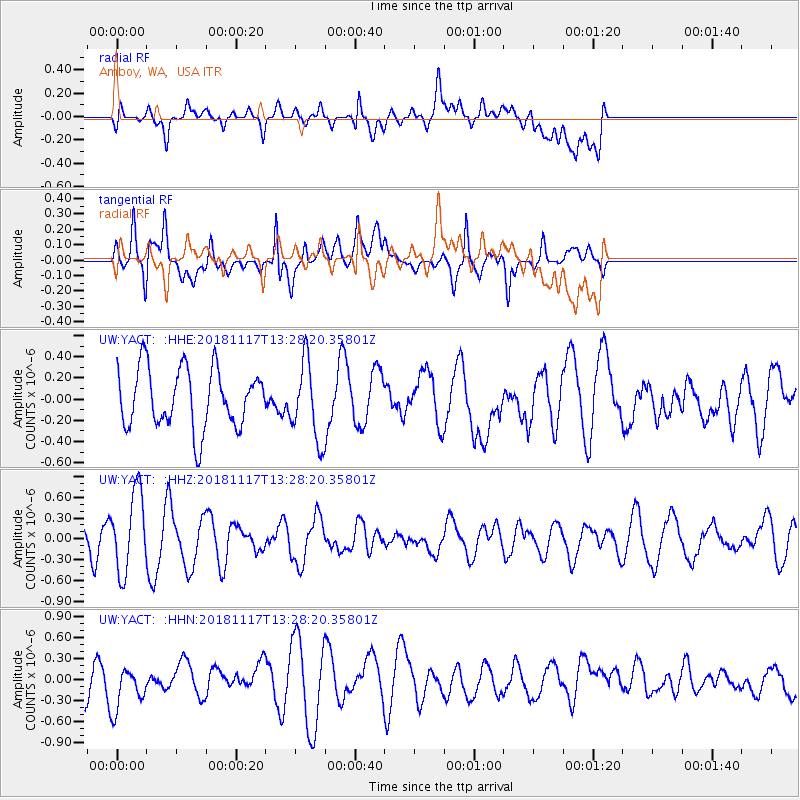
YACT Amboy, WA, USA - Earthquake Result Viewer
*The percent match for this event was below the threshold and hence no stack was calculated.
| Earthquake location: |
North Atlantic Ocean |
| Earthquake latitude/longitude: |
15.5/-49.9 |
| Earthquake time(UTC): |
2018/11/17 (321) 13:17:59 GMT |
| Earthquake Depth: |
10 km |
| Earthquake Magnitude: |
5.5 Mww |
| Earthquake Catalog/Contributor: |
NEIC PDE/us |
|
| Network: |
UW Pacific Northwest Regional Seismic Network |
| Station: |
YACT Amboy, WA, USA |
| Lat/Lon: |
45.93 N/122.42 W |
| Elevation: |
211 m |
|
| Distance: |
66.9 deg |
| Az: |
313.627 deg |
| Baz: |
91.348 deg |
| Ray Param: |
$rayparam |
*The percent match for this event was below the threshold and hence was not used in the summary stack. |
|
| Radial Match: |
39.196873 % |
| Radial Bump: |
400 |
| Transverse Match: |
61.187714 % |
| Transverse Bump: |
400 |
| SOD ConfigId: |
13570011 |
| Insert Time: |
2019-05-01 20:32:35.680 +0000 |
| GWidth: |
2.5 |
| Max Bumps: |
400 |
| Tol: |
0.001 |
|
Signal To Noise
| Channel | StoN | STA | LTA |
| UW:YACT: :HHZ:20181117T13:28:20.35801Z | 2.224816 | 5.7985415E-7 | 2.6063015E-7 |
| UW:YACT: :HHN:20181117T13:28:20.35801Z | 1.2701726 | 3.3252496E-7 | 2.6179512E-7 |
| UW:YACT: :HHE:20181117T13:28:20.35801Z | 1.2948891 | 3.6331707E-7 | 2.8057775E-7 |
| Arrivals |
| Ps | |
| PpPs | |
| PsPs/PpSs | |


