You are here: Home > Network List > TA - USArray Transportable Network (new EarthScope stations) Stations List
> Station Q14A Sevier Lake (BLM), Delta, UT, USA > Earthquake Result Viewer
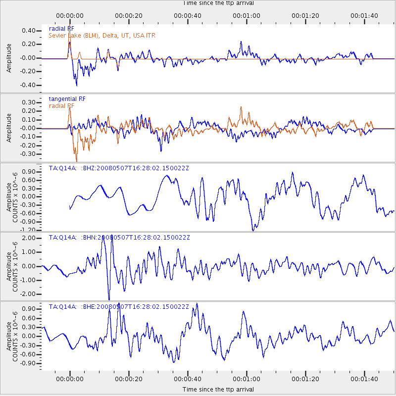
Q14A Sevier Lake (BLM), Delta, UT, USA - Earthquake Result Viewer
*The percent match for this event was below the threshold and hence no stack was calculated.
| Earthquake location: |
Near East Coast Of Honshu, Japan |
| Earthquake latitude/longitude: |
36.2/141.8 |
| Earthquake time(UTC): |
2008/05/07 (128) 16:16:36 GMT |
| Earthquake Depth: |
23 km |
| Earthquake Magnitude: |
5.9 MB, 6.1 MW, 6.0 MW |
| Earthquake Catalog/Contributor: |
WHDF/NEIC |
|
| Network: |
TA USArray Transportable Network (new EarthScope stations) |
| Station: |
Q14A Sevier Lake (BLM), Delta, UT, USA |
| Lat/Lon: |
38.99 N/113.28 W |
| Elevation: |
1464 m |
|
| Distance: |
78.2 deg |
| Az: |
50.288 deg |
| Baz: |
306.981 deg |
| Ray Param: |
$rayparam |
*The percent match for this event was below the threshold and hence was not used in the summary stack. |
|
| Radial Match: |
81.76218 % |
| Radial Bump: |
366 |
| Transverse Match: |
80.05026 % |
| Transverse Bump: |
400 |
| SOD ConfigId: |
2504 |
| Insert Time: |
2010-03-06 18:06:33.891 +0000 |
| GWidth: |
2.5 |
| Max Bumps: |
400 |
| Tol: |
0.001 |
|
Signal To Noise
| Channel | StoN | STA | LTA |
| TA:Q14A: :BHN:20080507T16:28:02.150022Z | 1.5420994 | 4.3566254E-7 | 2.8251262E-7 |
| TA:Q14A: :BHE:20080507T16:28:02.150022Z | 1.864416 | 2.6360723E-7 | 1.4138863E-7 |
| TA:Q14A: :BHZ:20080507T16:28:02.150022Z | 2.0181458 | 6.067218E-7 | 3.006333E-7 |
| Arrivals |
| Ps | |
| PpPs | |
| PsPs/PpSs | |


