You are here: Home > Network List > AK - Alaska Regional Network Stations List
> Station BRSE Bradley Lake South, AK, USA > Earthquake Result Viewer
BRSE Bradley Lake South, AK, USA - Earthquake Result Viewer
| Earthquake location: |
Fiji Islands Region |
| Earthquake latitude/longitude: |
-17.9/-178.9 |
| Earthquake time(UTC): |
2018/11/18 (322) 20:25:45 GMT |
| Earthquake Depth: |
534 km |
| Earthquake Magnitude: |
6.7 Mww |
| Earthquake Catalog/Contributor: |
NEIC PDE/us |
|
| Network: |
AK Alaska Regional Network |
| Station: |
BRSE Bradley Lake South, AK, USA |
| Lat/Lon: |
59.74 N/150.74 W |
| Elevation: |
541 m |
|
| Distance: |
80.7 deg |
| Az: |
14.015 deg |
| Baz: |
207.088 deg |
| Ray Param: |
0.046516318 |
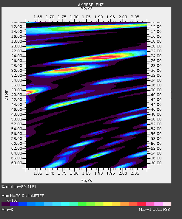
| Estimated Moho Depth: |
39.0 km |
| Estimated Crust Vp/Vs: |
1.60 |
| Assumed Crust Vp: |
6.24 km/s |
| Estimated Crust Vs: |
3.9 km/s |
| Estimated Crust Poisson's Ratio: |
0.18 |
|
| Radial Match: |
80.4181 % |
| Radial Bump: |
400 |
| Transverse Match: |
73.9355 % |
| Transverse Bump: |
400 |
| SOD ConfigId: |
13570011 |
| Insert Time: |
2019-05-01 20:34:50.654 +0000 |
| GWidth: |
2.5 |
| Max Bumps: |
400 |
| Tol: |
0.001 |
|

Signal To Noise
| Channel | StoN | STA | LTA |
| AK:BRSE: :BHZ:20181118T20:36:32.188018Z | 21.906378 | 1.0659594E-5 | 4.865978E-7 |
| AK:BRSE: :BHN:20181118T20:36:32.188018Z | 8.464316 | 3.6486929E-6 | 4.3106763E-7 |
| AK:BRSE: :BHE:20181118T20:36:32.188018Z | 6.15864 | 3.4383695E-6 | 5.5830014E-7 |
| Arrivals |
| Ps | 3.9 SECOND |
| PpPs | 16 SECOND |
| PsPs/PpSs | 20 SECOND |


