You are here: Home > Network List > TA - USArray Transportable Network (new EarthScope stations) Stations List
> Station Q14A Sevier Lake (BLM), Delta, UT, USA > Earthquake Result Viewer
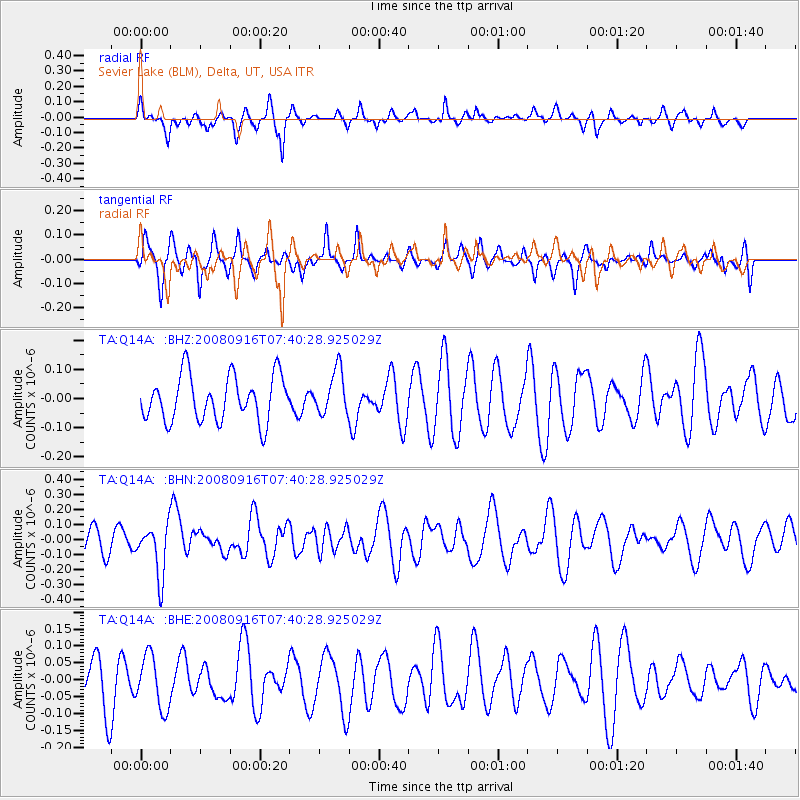
Q14A Sevier Lake (BLM), Delta, UT, USA - Earthquake Result Viewer
*The percent match for this event was below the threshold and hence no stack was calculated.
| Earthquake location: |
Central Mid-Atlantic Ridge |
| Earthquake latitude/longitude: |
0.9/-29.0 |
| Earthquake time(UTC): |
2008/09/16 (260) 07:28:25 GMT |
| Earthquake Depth: |
10 km |
| Earthquake Magnitude: |
5.8 MW, 5.2 MS, 5.2 MB, 5.8 MW |
| Earthquake Catalog/Contributor: |
WHDF/NEIC |
|
| Network: |
TA USArray Transportable Network (new EarthScope stations) |
| Station: |
Q14A Sevier Lake (BLM), Delta, UT, USA |
| Lat/Lon: |
38.99 N/113.28 W |
| Elevation: |
1464 m |
|
| Distance: |
85.0 deg |
| Az: |
308.882 deg |
| Baz: |
92.893 deg |
| Ray Param: |
$rayparam |
*The percent match for this event was below the threshold and hence was not used in the summary stack. |
|
| Radial Match: |
39.10317 % |
| Radial Bump: |
287 |
| Transverse Match: |
39.29754 % |
| Transverse Bump: |
291 |
| SOD ConfigId: |
2504 |
| Insert Time: |
2010-03-06 18:06:47.076 +0000 |
| GWidth: |
2.5 |
| Max Bumps: |
400 |
| Tol: |
0.001 |
|
Signal To Noise
| Channel | StoN | STA | LTA |
| TA:Q14A: :BHN:20080916T07:40:28.925029Z | 2.3531542 | 1.7481455E-7 | 7.428946E-8 |
| TA:Q14A: :BHE:20080916T07:40:28.925029Z | 1.0121832 | 7.8285986E-8 | 7.734369E-8 |
| TA:Q14A: :BHZ:20080916T07:40:28.925029Z | 0.96826184 | 7.523328E-8 | 7.769931E-8 |
| Arrivals |
| Ps | |
| PpPs | |
| PsPs/PpSs | |


