You are here: Home > Network List > AV - Alaska Volcano Observatory Stations List
> Station AU22 Augustine Mound, Augustine Volcano, Alaska > Earthquake Result Viewer
AU22 Augustine Mound, Augustine Volcano, Alaska - Earthquake Result Viewer
| Earthquake location: |
Fiji Islands Region |
| Earthquake latitude/longitude: |
-17.9/-178.9 |
| Earthquake time(UTC): |
2018/11/18 (322) 20:25:45 GMT |
| Earthquake Depth: |
534 km |
| Earthquake Magnitude: |
6.7 Mww |
| Earthquake Catalog/Contributor: |
NEIC PDE/us |
|
| Network: |
AV Alaska Volcano Observatory |
| Station: |
AU22 Augustine Mound, Augustine Volcano, Alaska |
| Lat/Lon: |
59.34 N/153.36 W |
| Elevation: |
105 m |
|
| Distance: |
79.7 deg |
| Az: |
12.978 deg |
| Baz: |
204.661 deg |
| Ray Param: |
0.04714727 |
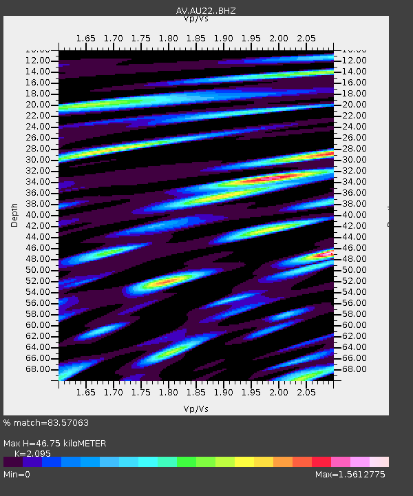
| Estimated Moho Depth: |
46.75 km |
| Estimated Crust Vp/Vs: |
2.10 |
| Assumed Crust Vp: |
5.989 km/s |
| Estimated Crust Vs: |
2.859 km/s |
| Estimated Crust Poisson's Ratio: |
0.35 |
|
| Radial Match: |
83.57063 % |
| Radial Bump: |
400 |
| Transverse Match: |
84.160385 % |
| Transverse Bump: |
400 |
| SOD ConfigId: |
13570011 |
| Insert Time: |
2019-05-01 20:36:31.221 +0000 |
| GWidth: |
2.5 |
| Max Bumps: |
400 |
| Tol: |
0.001 |
|

Signal To Noise
| Channel | StoN | STA | LTA |
| AV:AU22: :BHZ:20181118T20:36:27.418975Z | 15.057146 | 1.7081724E-5 | 1.1344596E-6 |
| AV:AU22: :BHN:20181118T20:36:27.418975Z | 2.9753485 | 5.399893E-6 | 1.8148774E-6 |
| AV:AU22: :BHE:20181118T20:36:27.418975Z | 1.8162398 | 3.236774E-6 | 1.7821292E-6 |
| Arrivals |
| Ps | 8.7 SECOND |
| PpPs | 24 SECOND |
| PsPs/PpSs | 32 SECOND |


