You are here: Home > Network List > AV - Alaska Volcano Observatory Stations List
> Station SPBL Spurr Beluga Lake, Mount Spur, Alaska > Earthquake Result Viewer
SPBL Spurr Beluga Lake, Mount Spur, Alaska - Earthquake Result Viewer
| Earthquake location: |
Fiji Islands Region |
| Earthquake latitude/longitude: |
-17.9/-178.9 |
| Earthquake time(UTC): |
2018/11/18 (322) 20:25:45 GMT |
| Earthquake Depth: |
534 km |
| Earthquake Magnitude: |
6.7 Mww |
| Earthquake Catalog/Contributor: |
NEIC PDE/us |
|
| Network: |
AV Alaska Volcano Observatory |
| Station: |
SPBL Spurr Beluga Lake, Mount Spur, Alaska |
| Lat/Lon: |
61.38 N/151.89 W |
| Elevation: |
927 m |
|
| Distance: |
81.9 deg |
| Az: |
12.759 deg |
| Baz: |
205.895 deg |
| Ray Param: |
0.04569423 |
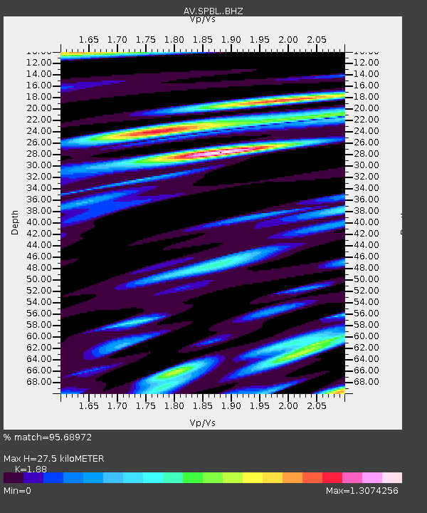
| Estimated Moho Depth: |
27.5 km |
| Estimated Crust Vp/Vs: |
1.88 |
| Assumed Crust Vp: |
6.302 km/s |
| Estimated Crust Vs: |
3.352 km/s |
| Estimated Crust Poisson's Ratio: |
0.30 |
|
| Radial Match: |
95.68972 % |
| Radial Bump: |
400 |
| Transverse Match: |
94.9375 % |
| Transverse Bump: |
400 |
| SOD ConfigId: |
13570011 |
| Insert Time: |
2019-05-01 20:36:54.089 +0000 |
| GWidth: |
2.5 |
| Max Bumps: |
400 |
| Tol: |
0.001 |
|

Signal To Noise
| Channel | StoN | STA | LTA |
| AV:SPBL: :BHZ:20181118T20:36:38.399016Z | 45.71925 | 6.8437785E-6 | 1.496914E-7 |
| AV:SPBL: :BHN:20181118T20:36:38.399016Z | 17.316206 | 2.3612738E-6 | 1.3636208E-7 |
| AV:SPBL: :BHE:20181118T20:36:38.399016Z | 9.282305 | 1.3680037E-6 | 1.4737759E-7 |
| Arrivals |
| Ps | 3.9 SECOND |
| PpPs | 12 SECOND |
| PsPs/PpSs | 16 SECOND |


