You are here: Home > Network List > TA - USArray Transportable Network (new EarthScope stations) Stations List
> Station S16A Weppner Ranch, Escalante, UT, USA > Earthquake Result Viewer
S16A Weppner Ranch, Escalante, UT, USA - Earthquake Result Viewer
| Earthquake location: |
Tonga Islands |
| Earthquake latitude/longitude: |
-21.9/-173.8 |
| Earthquake time(UTC): |
2008/10/19 (293) 05:10:33 GMT |
| Earthquake Depth: |
29 km |
| Earthquake Magnitude: |
6.8 MB, 7.0 MS, 6.9 MW, 6.9 MW |
| Earthquake Catalog/Contributor: |
WHDF/NEIC |
|
| Network: |
TA USArray Transportable Network (new EarthScope stations) |
| Station: |
S16A Weppner Ranch, Escalante, UT, USA |
| Lat/Lon: |
37.72 N/111.60 W |
| Elevation: |
1785 m |
|
| Distance: |
83.2 deg |
| Az: |
44.951 deg |
| Baz: |
235.858 deg |
| Ray Param: |
0.046293482 |
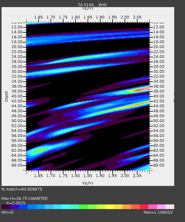
| Estimated Moho Depth: |
36.75 km |
| Estimated Crust Vp/Vs: |
2.09 |
| Assumed Crust Vp: |
6.247 km/s |
| Estimated Crust Vs: |
2.985 km/s |
| Estimated Crust Poisson's Ratio: |
0.35 |
|
| Radial Match: |
94.906975 % |
| Radial Bump: |
400 |
| Transverse Match: |
80.84859 % |
| Transverse Bump: |
400 |
| SOD ConfigId: |
2556 |
| Insert Time: |
2010-03-06 18:07:10.903 +0000 |
| GWidth: |
2.5 |
| Max Bumps: |
400 |
| Tol: |
0.001 |
|
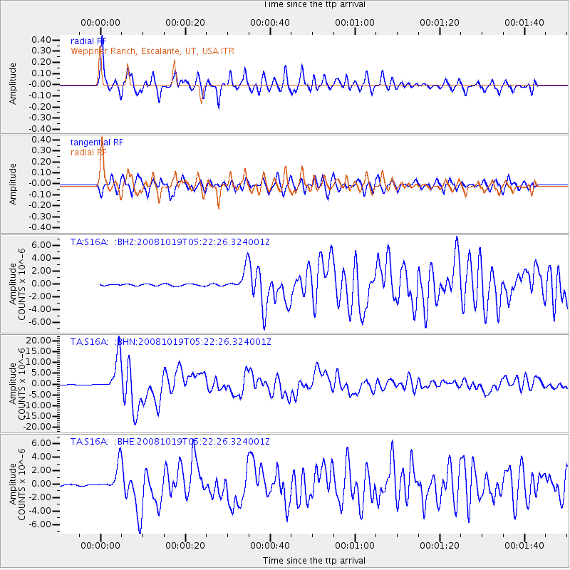
Signal To Noise
| Channel | StoN | STA | LTA |
| TA:S16A: :BHN:20081019T05:22:26.324001Z | 84.3182 | 8.459593E-6 | 1.0032939E-7 |
| TA:S16A: :BHE:20081019T05:22:26.324001Z | 20.261803 | 2.013494E-6 | 9.937388E-8 |
| TA:S16A: :BHZ:20081019T05:22:26.324001Z | 12.907298 | 1.7425197E-6 | 1.3500267E-7 |
| Arrivals |
| Ps | 6.6 SECOND |
| PpPs | 18 SECOND |
| PsPs/PpSs | 24 SECOND |


