You are here: Home > Network List > TA - USArray Transportable Network (new EarthScope stations) Stations List
> Station S16A Weppner Ranch, Escalante, UT, USA > Earthquake Result Viewer
S16A Weppner Ranch, Escalante, UT, USA - Earthquake Result Viewer
| Earthquake location: |
Central East Pacific Rise |
| Earthquake latitude/longitude: |
-9.0/-108.2 |
| Earthquake time(UTC): |
2008/10/30 (304) 15:15:41 GMT |
| Earthquake Depth: |
10 km |
| Earthquake Magnitude: |
5.5 MB, 5.8 MS, 6.0 MW, 6.0 MW |
| Earthquake Catalog/Contributor: |
WHDF/NEIC |
|
| Network: |
TA USArray Transportable Network (new EarthScope stations) |
| Station: |
S16A Weppner Ranch, Escalante, UT, USA |
| Lat/Lon: |
37.72 N/111.60 W |
| Elevation: |
1785 m |
|
| Distance: |
46.6 deg |
| Az: |
356.344 deg |
| Baz: |
175.443 deg |
| Ray Param: |
0.07054238 |
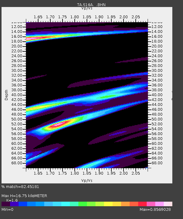
| Estimated Moho Depth: |
16.75 km |
| Estimated Crust Vp/Vs: |
1.60 |
| Assumed Crust Vp: |
6.247 km/s |
| Estimated Crust Vs: |
3.904 km/s |
| Estimated Crust Poisson's Ratio: |
0.18 |
|
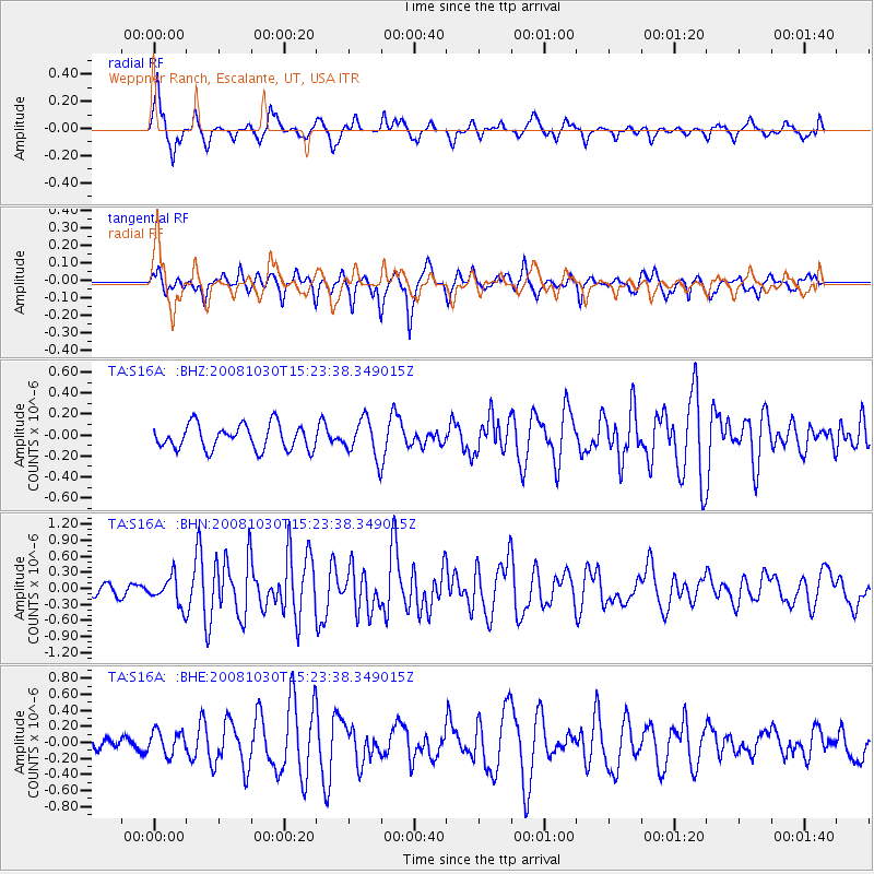
| Radial Match: |
82.45181 % |
| Radial Bump: |
345 |
| Transverse Match: |
67.92559 % |
| Transverse Bump: |
400 |
| SOD ConfigId: |
2560 |
| Insert Time: |
2010-03-06 18:07:24.073 +0000 |
| GWidth: |
2.5 |
| Max Bumps: |
400 |
| Tol: |
0.001 |
|
Signal To Noise
| Channel | StoN | STA | LTA |
| TA:S16A: :BHN:20081030T15:23:38.349015Z | 2.2361457 | 2.6353965E-7 | 1.1785442E-7 |
| TA:S16A: :BHE:20081030T15:23:38.349015Z | 0.92926383 | 1.4637935E-7 | 1.5752184E-7 |
| TA:S16A: :BHZ:20081030T15:23:38.349015Z | 1.5357609 | 1.8006051E-7 | 1.1724514E-7 |
| Arrivals |
| Ps | 1.7 SECOND |
| PpPs | 6.5 SECOND |
| PsPs/PpSs | 8.2 SECOND |


