You are here: Home > Network List > TA - USArray Transportable Network (new EarthScope stations) Stations List
> Station S16A Weppner Ranch, Escalante, UT, USA > Earthquake Result Viewer
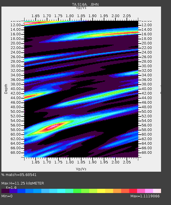
S16A Weppner Ranch, Escalante, UT, USA - Earthquake Result Viewer
| Earthquake location: |
Andreanof Islands, Aleutian Is. |
| Earthquake latitude/longitude: |
51.4/-179.0 |
| Earthquake time(UTC): |
2007/12/21 (355) 07:24:34 GMT |
| Earthquake Depth: |
30 km |
| Earthquake Magnitude: |
6.1 MB, 6.2 MW, 6.3 ML |
| Earthquake Catalog/Contributor: |
WHDF/NEIC |
|
| Network: |
TA USArray Transportable Network (new EarthScope stations) |
| Station: |
S16A Weppner Ranch, Escalante, UT, USA |
| Lat/Lon: |
37.72 N/111.60 W |
| Elevation: |
1785 m |
|
| Distance: |
48.3 deg |
| Az: |
78.84 deg |
| Baz: |
309.128 deg |
| Ray Param: |
0.069426134 |
| Estimated Moho Depth: |
11.25 km |
| Estimated Crust Vp/Vs: |
1.60 |
| Assumed Crust Vp: |
6.247 km/s |
| Estimated Crust Vs: |
3.904 km/s |
| Estimated Crust Poisson's Ratio: |
0.18 |
|
| Radial Match: |
85.68541 % |
| Radial Bump: |
400 |
| Transverse Match: |
75.32059 % |
| Transverse Bump: |
400 |
| SOD ConfigId: |
2564 |
| Insert Time: |
2010-03-06 18:07:35.784 +0000 |
| GWidth: |
2.5 |
| Max Bumps: |
400 |
| Tol: |
0.001 |
|

Signal To Noise
| Channel | StoN | STA | LTA |
| TA:S16A: :BHN:20071221T07:32:42.173014Z | 0.99367046 | 2.3154705E-7 | 2.3302198E-7 |
| TA:S16A: :BHE:20071221T07:32:42.173014Z | 1.3231723 | 4.6145402E-7 | 3.4874824E-7 |
| TA:S16A: :BHZ:20071221T07:32:42.173014Z | 3.0707195 | 1.0744645E-6 | 3.4990643E-7 |
| Arrivals |
| Ps | 1.2 SECOND |
| PpPs | 4.4 SECOND |
| PsPs/PpSs | 5.5 SECOND |


