You are here: Home > Network List > TA - USArray Transportable Network (new EarthScope stations) Stations List
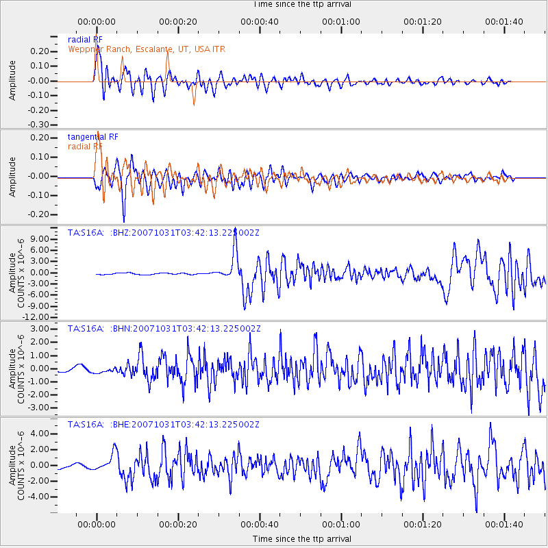
> Station S16A Weppner Ranch, Escalante, UT, USA > Earthquake Result Viewer
S16A Weppner Ranch, Escalante, UT, USA - Earthquake Result Viewer
| Earthquake location: |
Mariana Islands |
| Earthquake latitude/longitude: |
18.9/145.4 |
| Earthquake time(UTC): |
2007/10/31 (304) 03:30:17 GMT |
| Earthquake Depth: |
223 km |
| Earthquake Magnitude: |
6.2 MB, 7.2 MW, 7.2 MW |
| Earthquake Catalog/Contributor: |
WHDF/NEIC |
|
| Network: |
TA USArray Transportable Network (new EarthScope stations) |
| Station: |
S16A Weppner Ranch, Escalante, UT, USA |
| Lat/Lon: |
37.72 N/111.60 W |
| Elevation: |
1785 m |
|
| Distance: |
88.5 deg |
| Az: |
50.605 deg |
| Baz: |
292.679 deg |
| Ray Param: |
0.042042956 |
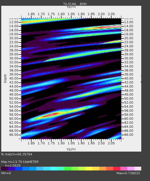
| Estimated Moho Depth: |
13.75 km |
| Estimated Crust Vp/Vs: |
2.08 |
| Assumed Crust Vp: |
6.247 km/s |
| Estimated Crust Vs: |
3.0 km/s |
| Estimated Crust Poisson's Ratio: |
0.35 |
|
| Radial Match: |
88.35784 % |
| Radial Bump: |
400 |
| Transverse Match: |
86.60828 % |
| Transverse Bump: |
400 |
| SOD ConfigId: |
2564 |
| Insert Time: |
2010-03-06 18:07:41.325 +0000 |
| GWidth: |
2.5 |
| Max Bumps: |
400 |
| Tol: |
0.001 |
|
Signal To Noise
| Channel | StoN | STA | LTA |
| TA:S16A: :BHN:20071031T03:42:13.225002Z | 1.3242856 | 2.1263062E-7 | 1.6056252E-7 |
| TA:S16A: :BHE:20071031T03:42:13.225002Z | 4.440662 | 1.1707178E-6 | 2.6363588E-7 |
| TA:S16A: :BHZ:20071031T03:42:13.225002Z | 21.06795 | 4.1749577E-6 | 1.9816629E-7 |
| Arrivals |
| Ps | 2.4 SECOND |
| PpPs | 6.7 SECOND |
| PsPs/PpSs | 9.1 SECOND |


