You are here: Home > Network List > TA - USArray Transportable Network (new EarthScope stations) Stations List
> Station S16A Weppner Ranch, Escalante, UT, USA > Earthquake Result Viewer
S16A Weppner Ranch, Escalante, UT, USA - Earthquake Result Viewer
| Earthquake location: |
Kuril Islands |
| Earthquake latitude/longitude: |
45.8/150.1 |
| Earthquake time(UTC): |
2007/09/03 (246) 16:14:53 GMT |
| Earthquake Depth: |
94 km |
| Earthquake Magnitude: |
6.3 MB, 6.2 MW, 6.2 ME |
| Earthquake Catalog/Contributor: |
WHDF/NEIC |
|
| Network: |
TA USArray Transportable Network (new EarthScope stations) |
| Station: |
S16A Weppner Ranch, Escalante, UT, USA |
| Lat/Lon: |
37.72 N/111.60 W |
| Elevation: |
1785 m |
|
| Distance: |
69.2 deg |
| Az: |
57.066 deg |
| Baz: |
312.272 deg |
| Ray Param: |
0.05557289 |
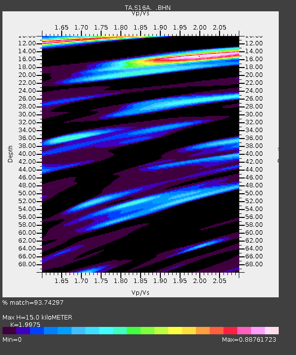
| Estimated Moho Depth: |
15.0 km |
| Estimated Crust Vp/Vs: |
2.00 |
| Assumed Crust Vp: |
6.247 km/s |
| Estimated Crust Vs: |
3.127 km/s |
| Estimated Crust Poisson's Ratio: |
0.33 |
|
| Radial Match: |
93.74297 % |
| Radial Bump: |
400 |
| Transverse Match: |
89.3732 % |
| Transverse Bump: |
400 |
| SOD ConfigId: |
2564 |
| Insert Time: |
2010-03-06 18:07:48.828 +0000 |
| GWidth: |
2.5 |
| Max Bumps: |
400 |
| Tol: |
0.001 |
|
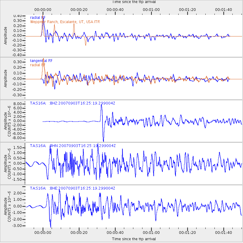
Signal To Noise
| Channel | StoN | STA | LTA |
| TA:S16A: :BHN:20070903T16:25:19.299004Z | 7.0846057 | 7.64488E-7 | 1.07908335E-7 |
| TA:S16A: :BHE:20070903T16:25:19.299004Z | 15.009281 | 1.2142028E-6 | 8.08968E-8 |
| TA:S16A: :BHZ:20070903T16:25:19.299004Z | 40.754055 | 4.005571E-6 | 9.828644E-8 |
| Arrivals |
| Ps | 2.5 SECOND |
| PpPs | 7.0 SECOND |
| PsPs/PpSs | 9.4 SECOND |


