You are here: Home > Network List > TA - USArray Transportable Network (new EarthScope stations) Stations List
> Station S16A Weppner Ranch, Escalante, UT, USA > Earthquake Result Viewer
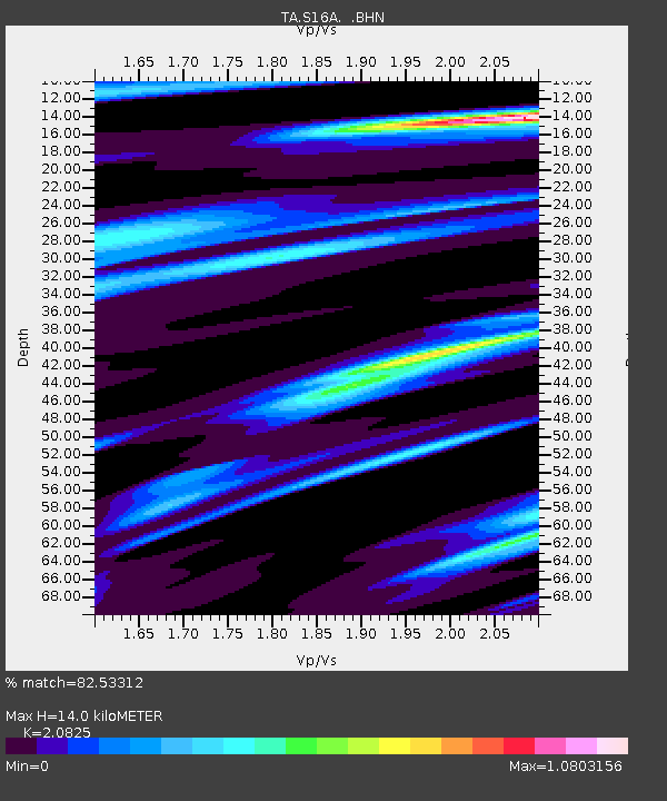
S16A Weppner Ranch, Escalante, UT, USA - Earthquake Result Viewer
| Earthquake location: |
Andreanof Islands, Aleutian Is. |
| Earthquake latitude/longitude: |
50.3/-177.5 |
| Earthquake time(UTC): |
2007/08/15 (227) 20:22:11 GMT |
| Earthquake Depth: |
9.0 km |
| Earthquake Magnitude: |
6.3 MB, 6.2 MS, 6.4 MW, 5.9 ML |
| Earthquake Catalog/Contributor: |
WHDF/NEIC |
|
| Network: |
TA USArray Transportable Network (new EarthScope stations) |
| Station: |
S16A Weppner Ranch, Escalante, UT, USA |
| Lat/Lon: |
37.72 N/111.60 W |
| Elevation: |
1785 m |
|
| Distance: |
47.6 deg |
| Az: |
78.865 deg |
| Baz: |
307.519 deg |
| Ray Param: |
0.06990963 |
| Estimated Moho Depth: |
14.0 km |
| Estimated Crust Vp/Vs: |
2.08 |
| Assumed Crust Vp: |
6.247 km/s |
| Estimated Crust Vs: |
3.0 km/s |
| Estimated Crust Poisson's Ratio: |
0.35 |
|
| Radial Match: |
82.53312 % |
| Radial Bump: |
400 |
| Transverse Match: |
79.51035 % |
| Transverse Bump: |
390 |
| SOD ConfigId: |
2564 |
| Insert Time: |
2010-03-06 18:07:52.403 +0000 |
| GWidth: |
2.5 |
| Max Bumps: |
400 |
| Tol: |
0.001 |
|

Signal To Noise
| Channel | StoN | STA | LTA |
| TA:S16A: :BHN:20070815T20:30:15.975011Z | 0.91445696 | 8.7720144E-7 | 9.592594E-7 |
| TA:S16A: :BHE:20070815T20:30:15.975011Z | 1.9775348 | 1.300831E-6 | 6.578044E-7 |
| TA:S16A: :BHZ:20070815T20:30:15.975011Z | 4.1406264 | 3.1301263E-6 | 7.5595483E-7 |
| Arrivals |
| Ps | 2.5 SECOND |
| PpPs | 6.6 SECOND |
| PsPs/PpSs | 9.1 SECOND |


