You are here: Home > Network List > TA - USArray Transportable Network (new EarthScope stations) Stations List
> Station S16A Weppner Ranch, Escalante, UT, USA > Earthquake Result Viewer
S16A Weppner Ranch, Escalante, UT, USA - Earthquake Result Viewer
| Earthquake location: |
Rat Islands, Aleutian Islands |
| Earthquake latitude/longitude: |
51.2/178.8 |
| Earthquake time(UTC): |
2008/05/20 (141) 13:53:35 GMT |
| Earthquake Depth: |
27 km |
| Earthquake Magnitude: |
5.8 MB, 6.0 MS, 6.3 MW, 6.3 MW |
| Earthquake Catalog/Contributor: |
WHDF/NEIC |
|
| Network: |
TA USArray Transportable Network (new EarthScope stations) |
| Station: |
S16A Weppner Ranch, Escalante, UT, USA |
| Lat/Lon: |
37.72 N/111.60 W |
| Elevation: |
1785 m |
|
| Distance: |
49.7 deg |
| Az: |
77.167 deg |
| Baz: |
309.264 deg |
| Ray Param: |
0.06849843 |
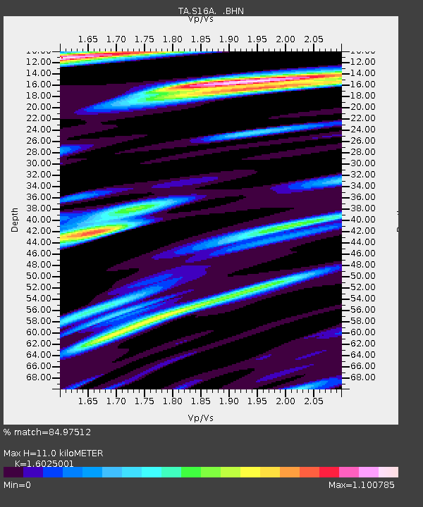
| Estimated Moho Depth: |
11.0 km |
| Estimated Crust Vp/Vs: |
1.60 |
| Assumed Crust Vp: |
6.247 km/s |
| Estimated Crust Vs: |
3.898 km/s |
| Estimated Crust Poisson's Ratio: |
0.18 |
|
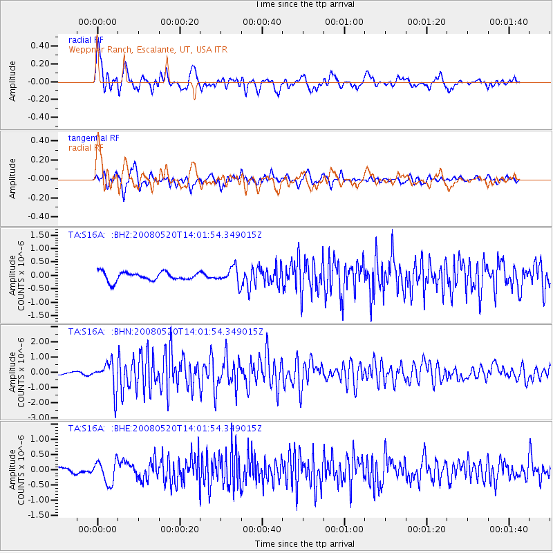
| Radial Match: |
84.97512 % |
| Radial Bump: |
400 |
| Transverse Match: |
77.2052 % |
| Transverse Bump: |
400 |
| SOD ConfigId: |
2504 |
| Insert Time: |
2010-03-06 18:08:09.552 +0000 |
| GWidth: |
2.5 |
| Max Bumps: |
400 |
| Tol: |
0.001 |
|
Signal To Noise
| Channel | StoN | STA | LTA |
| TA:S16A: :BHN:20080520T14:01:54.349015Z | 8.91348 | 9.429109E-7 | 1.0578483E-7 |
| TA:S16A: :BHE:20080520T14:01:54.349015Z | 3.2945158 | 3.8017524E-7 | 1.15396396E-7 |
| TA:S16A: :BHZ:20080520T14:01:54.349015Z | 1.9739815 | 3.1427766E-7 | 1.5921003E-7 |
| Arrivals |
| Ps | 1.1 SECOND |
| PpPs | 4.3 SECOND |
| PsPs/PpSs | 5.4 SECOND |


