You are here: Home > Network List > N4 - Central and EAstern US Network Stations List
> Station SUSD Miller, SD, USA > Earthquake Result Viewer
SUSD Miller, SD, USA - Earthquake Result Viewer
| Earthquake location: |
Fiji Islands Region |
| Earthquake latitude/longitude: |
-17.9/-178.9 |
| Earthquake time(UTC): |
2018/11/18 (322) 20:25:45 GMT |
| Earthquake Depth: |
534 km |
| Earthquake Magnitude: |
6.7 Mww |
| Earthquake Catalog/Contributor: |
NEIC PDE/us |
|
| Network: |
N4 Central and EAstern US Network |
| Station: |
SUSD Miller, SD, USA |
| Lat/Lon: |
44.44 N/98.96 W |
| Elevation: |
520 m |
|
| Distance: |
95.4 deg |
| Az: |
45.108 deg |
| Baz: |
250.349 deg |
| Ray Param: |
0.04025073 |
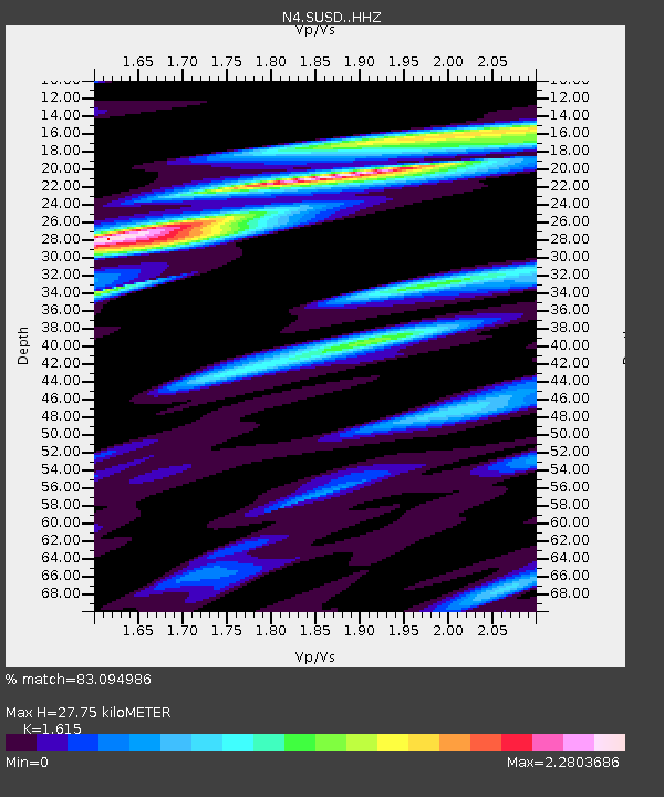
| Estimated Moho Depth: |
27.75 km |
| Estimated Crust Vp/Vs: |
1.62 |
| Assumed Crust Vp: |
6.53 km/s |
| Estimated Crust Vs: |
4.044 km/s |
| Estimated Crust Poisson's Ratio: |
0.19 |
|
| Radial Match: |
83.094986 % |
| Radial Bump: |
400 |
| Transverse Match: |
41.36136 % |
| Transverse Bump: |
400 |
| SOD ConfigId: |
13570011 |
| Insert Time: |
2019-05-01 20:41:48.453 +0000 |
| GWidth: |
2.5 |
| Max Bumps: |
400 |
| Tol: |
0.001 |
|

Signal To Noise
| Channel | StoN | STA | LTA |
| N4:SUSD: :HHZ:20181118T20:37:41.73001Z | 2.9245362 | 1.6695003E-6 | 5.7085987E-7 |
| N4:SUSD: :HHN:20181118T20:37:41.73001Z | 2.122503 | 6.8174506E-7 | 3.2119863E-7 |
| N4:SUSD: :HHE:20181118T20:37:41.73001Z | 2.5766163 | 1.5528258E-6 | 6.0266086E-7 |
| Arrivals |
| Ps | 2.7 SECOND |
| PpPs | 11 SECOND |
| PsPs/PpSs | 14 SECOND |


