You are here: Home > Network List > TA - USArray Transportable Network (new EarthScope stations) Stations List
> Station A21K Barrow, AK, USA > Earthquake Result Viewer
A21K Barrow, AK, USA - Earthquake Result Viewer
| Earthquake location: |
Fiji Islands Region |
| Earthquake latitude/longitude: |
-17.9/-178.9 |
| Earthquake time(UTC): |
2018/11/18 (322) 20:25:45 GMT |
| Earthquake Depth: |
534 km |
| Earthquake Magnitude: |
6.7 Mww |
| Earthquake Catalog/Contributor: |
NEIC PDE/us |
|
| Network: |
TA USArray Transportable Network (new EarthScope stations) |
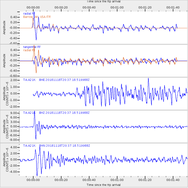
| Station: |
A21K Barrow, AK, USA |
| Lat/Lon: |
71.32 N/156.62 W |
| Elevation: |
577 m |
|
| Distance: |
90.3 deg |
| Az: |
7.017 deg |
| Baz: |
201.165 deg |
| Ray Param: |
0.04148035 |
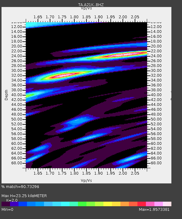
| Estimated Moho Depth: |
23.25 km |
| Estimated Crust Vp/Vs: |
2.00 |
| Assumed Crust Vp: |
6.048 km/s |
| Estimated Crust Vs: |
3.024 km/s |
| Estimated Crust Poisson's Ratio: |
0.33 |
|
| Radial Match: |
90.73296 % |
| Radial Bump: |
298 |
| Transverse Match: |
84.864136 % |
| Transverse Bump: |
314 |
| SOD ConfigId: |
13570011 |
| Insert Time: |
2019-05-01 20:44:15.133 +0000 |
| GWidth: |
2.5 |
| Max Bumps: |
400 |
| Tol: |
0.001 |
|
Signal To Noise
| Channel | StoN | STA | LTA |
| TA:A21K: :BHZ:20181118T20:37:18.519988Z | 22.85625 | 3.984057E-6 | 1.7430929E-7 |
| TA:A21K: :BHN:20181118T20:37:18.519988Z | 9.495584 | 2.4063797E-6 | 2.5342092E-7 |
| TA:A21K: :BHE:20181118T20:37:18.519988Z | 2.2991686 | 3.7505782E-7 | 1.631276E-7 |
| Arrivals |
| Ps | 3.9 SECOND |
| PpPs | 11 SECOND |
| PsPs/PpSs | 15 SECOND |


