You are here: Home > Network List > TA - USArray Transportable Network (new EarthScope stations) Stations List
> Station B22K Teshekpuk Lake, AK, USA > Earthquake Result Viewer
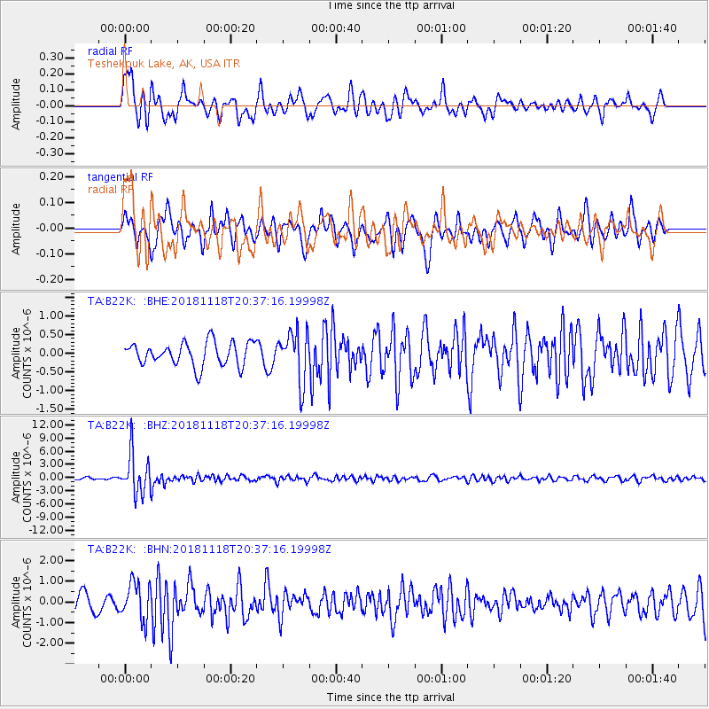
B22K Teshekpuk Lake, AK, USA - Earthquake Result Viewer
*The percent match for this event was below the threshold and hence no stack was calculated.
| Earthquake location: |
Fiji Islands Region |
| Earthquake latitude/longitude: |
-17.9/-178.9 |
| Earthquake time(UTC): |
2018/11/18 (322) 20:25:45 GMT |
| Earthquake Depth: |
534 km |
| Earthquake Magnitude: |
6.7 Mww |
| Earthquake Catalog/Contributor: |
NEIC PDE/us |
|
| Network: |
TA USArray Transportable Network (new EarthScope stations) |
| Station: |
B22K Teshekpuk Lake, AK, USA |
| Lat/Lon: |
70.34 N/153.42 W |
| Elevation: |
50 m |
|
| Distance: |
89.8 deg |
| Az: |
8.372 deg |
| Baz: |
204.183 deg |
| Ray Param: |
$rayparam |
*The percent match for this event was below the threshold and hence was not used in the summary stack. |
|
| Radial Match: |
79.10548 % |
| Radial Bump: |
400 |
| Transverse Match: |
63.254185 % |
| Transverse Bump: |
354 |
| SOD ConfigId: |
13570011 |
| Insert Time: |
2019-05-01 20:44:19.345 +0000 |
| GWidth: |
2.5 |
| Max Bumps: |
400 |
| Tol: |
0.001 |
|
Signal To Noise
| Channel | StoN | STA | LTA |
| TA:B22K: :BHZ:20181118T20:37:16.19998Z | 26.643085 | 4.5786937E-6 | 1.7185297E-7 |
| TA:B22K: :BHN:20181118T20:37:16.19998Z | 2.7625413 | 9.063901E-7 | 3.281001E-7 |
| TA:B22K: :BHE:20181118T20:37:16.19998Z | 2.1747785 | 6.8426357E-7 | 3.1463597E-7 |
| Arrivals |
| Ps | |
| PpPs | |
| PsPs/PpSs | |


