You are here: Home > Network List > TA - USArray Transportable Network (new EarthScope stations) Stations List
> Station D23K Nanushuk River, AK USA > Earthquake Result Viewer
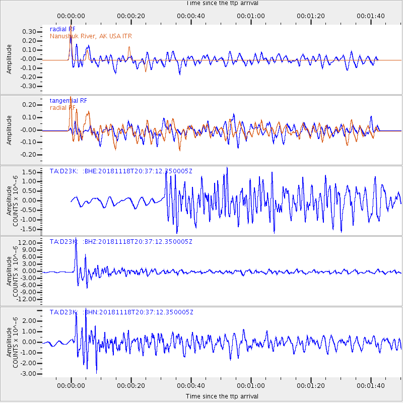
D23K Nanushuk River, AK USA - Earthquake Result Viewer
*The percent match for this event was below the threshold and hence no stack was calculated.
| Earthquake location: |
Fiji Islands Region |
| Earthquake latitude/longitude: |
-17.9/-178.9 |
| Earthquake time(UTC): |
2018/11/18 (322) 20:25:45 GMT |
| Earthquake Depth: |
534 km |
| Earthquake Magnitude: |
6.7 Mww |
| Earthquake Catalog/Contributor: |
NEIC PDE/us |
|
| Network: |
TA USArray Transportable Network (new EarthScope stations) |
| Station: |
D23K Nanushuk River, AK USA |
| Lat/Lon: |
68.97 N/150.68 W |
| Elevation: |
406 m |
|
| Distance: |
89.0 deg |
| Az: |
9.831 deg |
| Baz: |
206.764 deg |
| Ray Param: |
$rayparam |
*The percent match for this event was below the threshold and hence was not used in the summary stack. |
|
| Radial Match: |
78.91339 % |
| Radial Bump: |
400 |
| Transverse Match: |
73.362755 % |
| Transverse Bump: |
400 |
| SOD ConfigId: |
13570011 |
| Insert Time: |
2019-05-01 20:44:33.215 +0000 |
| GWidth: |
2.5 |
| Max Bumps: |
400 |
| Tol: |
0.001 |
|
Signal To Noise
| Channel | StoN | STA | LTA |
| TA:D23K: :BHZ:20181118T20:37:12.350005Z | 31.211548 | 4.3871205E-6 | 1.4056081E-7 |
| TA:D23K: :BHN:20181118T20:37:12.350005Z | 7.388658 | 1.0972954E-6 | 1.4851078E-7 |
| TA:D23K: :BHE:20181118T20:37:12.350005Z | 4.2972264 | 7.091192E-7 | 1.6501787E-7 |
| Arrivals |
| Ps | |
| PpPs | |
| PsPs/PpSs | |


