You are here: Home > Network List > TA - USArray Transportable Network (new EarthScope stations) Stations List
> Station D27M Malcolm River, YT, CAN > Earthquake Result Viewer
D27M Malcolm River, YT, CAN - Earthquake Result Viewer
| Earthquake location: |
Fiji Islands Region |
| Earthquake latitude/longitude: |
-17.9/-178.9 |
| Earthquake time(UTC): |
2018/11/18 (322) 20:25:45 GMT |
| Earthquake Depth: |
534 km |
| Earthquake Magnitude: |
6.7 Mww |
| Earthquake Catalog/Contributor: |
NEIC PDE/us |
|
| Network: |
TA USArray Transportable Network (new EarthScope stations) |
| Station: |
D27M Malcolm River, YT, CAN |
| Lat/Lon: |
69.24 N/140.96 W |
| Elevation: |
896 m |
|
| Distance: |
91.0 deg |
| Az: |
12.662 deg |
| Baz: |
215.837 deg |
| Ray Param: |
0.041348763 |
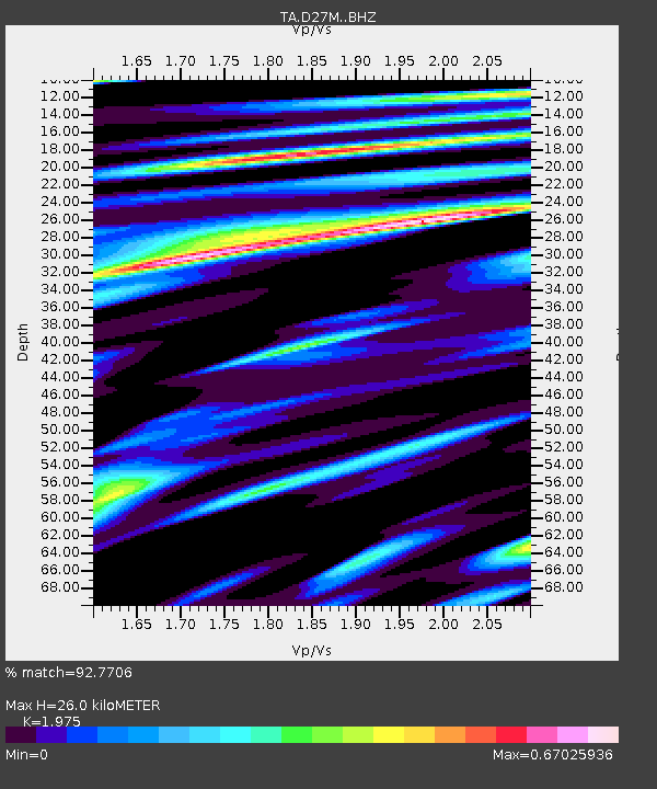
| Estimated Moho Depth: |
26.0 km |
| Estimated Crust Vp/Vs: |
1.98 |
| Assumed Crust Vp: |
6.522 km/s |
| Estimated Crust Vs: |
3.302 km/s |
| Estimated Crust Poisson's Ratio: |
0.33 |
|
| Radial Match: |
92.7706 % |
| Radial Bump: |
372 |
| Transverse Match: |
89.59593 % |
| Transverse Bump: |
342 |
| SOD ConfigId: |
13570011 |
| Insert Time: |
2019-05-01 20:44:34.317 +0000 |
| GWidth: |
2.5 |
| Max Bumps: |
400 |
| Tol: |
0.001 |
|

Signal To Noise
| Channel | StoN | STA | LTA |
| TA:D27M: :BHZ:20181118T20:37:21.774993Z | 33.13595 | 3.4424052E-6 | 1.03887324E-7 |
| TA:D27M: :BHN:20181118T20:37:21.774993Z | 15.79422 | 7.6782356E-7 | 4.861421E-8 |
| TA:D27M: :BHE:20181118T20:37:21.774993Z | 4.744506 | 5.284434E-7 | 1.1138008E-7 |
| Arrivals |
| Ps | 4.0 SECOND |
| PpPs | 12 SECOND |
| PsPs/PpSs | 16 SECOND |


