You are here: Home > Network List > TA - USArray Transportable Network (new EarthScope stations) Stations List
> Station E22K Anaktuvuk Pass, AK, USA > Earthquake Result Viewer
E22K Anaktuvuk Pass, AK, USA - Earthquake Result Viewer
| Earthquake location: |
Fiji Islands Region |
| Earthquake latitude/longitude: |
-17.9/-178.9 |
| Earthquake time(UTC): |
2018/11/18 (322) 20:25:45 GMT |
| Earthquake Depth: |
534 km |
| Earthquake Magnitude: |
6.7 Mww |
| Earthquake Catalog/Contributor: |
NEIC PDE/us |
|
| Network: |
TA USArray Transportable Network (new EarthScope stations) |
| Station: |
E22K Anaktuvuk Pass, AK, USA |
| Lat/Lon: |
68.13 N/151.81 W |
| Elevation: |
772 m |
|
| Distance: |
88.0 deg |
| Az: |
9.827 deg |
| Baz: |
205.711 deg |
| Ray Param: |
0.041702304 |
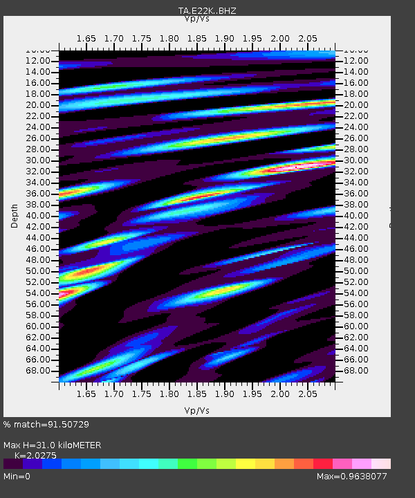
| Estimated Moho Depth: |
31.0 km |
| Estimated Crust Vp/Vs: |
2.03 |
| Assumed Crust Vp: |
6.221 km/s |
| Estimated Crust Vs: |
3.068 km/s |
| Estimated Crust Poisson's Ratio: |
0.34 |
|
| Radial Match: |
91.50729 % |
| Radial Bump: |
400 |
| Transverse Match: |
85.049 % |
| Transverse Bump: |
400 |
| SOD ConfigId: |
13570011 |
| Insert Time: |
2019-05-01 20:44:40.043 +0000 |
| GWidth: |
2.5 |
| Max Bumps: |
400 |
| Tol: |
0.001 |
|

Signal To Noise
| Channel | StoN | STA | LTA |
| TA:E22K: :BHZ:20181118T20:37:08.024993Z | 35.743343 | 4.404923E-6 | 1.2323758E-7 |
| TA:E22K: :BHN:20181118T20:37:08.024993Z | 16.843868 | 1.4023104E-6 | 8.325347E-8 |
| TA:E22K: :BHE:20181118T20:37:08.024993Z | 6.7229986 | 7.003316E-7 | 1.0416953E-7 |
| Arrivals |
| Ps | 5.2 SECOND |
| PpPs | 15 SECOND |
| PsPs/PpSs | 20 SECOND |


