You are here: Home > Network List > TA - USArray Transportable Network (new EarthScope stations) Stations List
> Station G19K Purcell Mountains, AK, USA > Earthquake Result Viewer
G19K Purcell Mountains, AK, USA - Earthquake Result Viewer
| Earthquake location: |
Fiji Islands Region |
| Earthquake latitude/longitude: |
-17.9/-178.9 |
| Earthquake time(UTC): |
2018/11/18 (322) 20:25:45 GMT |
| Earthquake Depth: |
534 km |
| Earthquake Magnitude: |
6.7 Mww |
| Earthquake Catalog/Contributor: |
NEIC PDE/us |
|
| Network: |
TA USArray Transportable Network (new EarthScope stations) |
| Station: |
G19K Purcell Mountains, AK, USA |
| Lat/Lon: |
66.14 N/157.09 W |
| Elevation: |
391 m |
|
| Distance: |
85.4 deg |
| Az: |
8.721 deg |
| Baz: |
200.792 deg |
| Ray Param: |
0.043300197 |
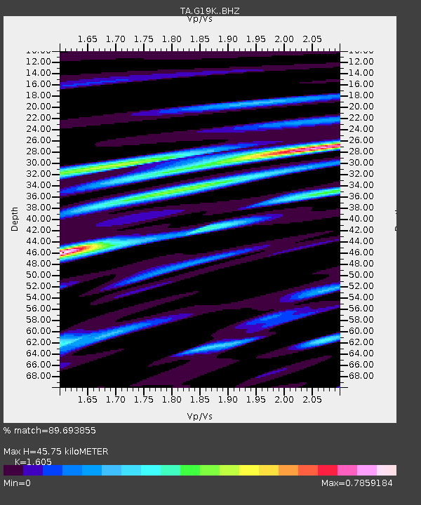
| Estimated Moho Depth: |
45.75 km |
| Estimated Crust Vp/Vs: |
1.61 |
| Assumed Crust Vp: |
6.577 km/s |
| Estimated Crust Vs: |
4.098 km/s |
| Estimated Crust Poisson's Ratio: |
0.18 |
|
| Radial Match: |
89.693855 % |
| Radial Bump: |
400 |
| Transverse Match: |
84.23231 % |
| Transverse Bump: |
400 |
| SOD ConfigId: |
13570011 |
| Insert Time: |
2019-05-01 20:45:00.375 +0000 |
| GWidth: |
2.5 |
| Max Bumps: |
400 |
| Tol: |
0.001 |
|

Signal To Noise
| Channel | StoN | STA | LTA |
| TA:G19K: :BHZ:20181118T20:36:55.550017Z | 40.80406 | 4.59234E-6 | 1.1254615E-7 |
| TA:G19K: :BHN:20181118T20:36:55.550017Z | 12.719697 | 1.6156303E-6 | 1.2701798E-7 |
| TA:G19K: :BHE:20181118T20:36:55.550017Z | 7.8326445 | 8.3041004E-7 | 1.06019115E-7 |
| Arrivals |
| Ps | 4.3 SECOND |
| PpPs | 18 SECOND |
| PsPs/PpSs | 22 SECOND |


