You are here: Home > Network List > TA - USArray Transportable Network (new EarthScope stations) Stations List
> Station S16A Weppner Ranch, Escalante, UT, USA > Earthquake Result Viewer
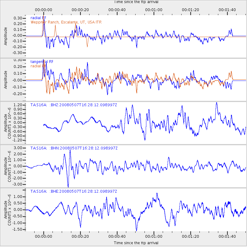
S16A Weppner Ranch, Escalante, UT, USA - Earthquake Result Viewer
*The percent match for this event was below the threshold and hence no stack was calculated.
| Earthquake location: |
Near East Coast Of Honshu, Japan |
| Earthquake latitude/longitude: |
36.2/141.8 |
| Earthquake time(UTC): |
2008/05/07 (128) 16:16:36 GMT |
| Earthquake Depth: |
23 km |
| Earthquake Magnitude: |
5.9 MB, 6.1 MW, 6.0 MW |
| Earthquake Catalog/Contributor: |
WHDF/NEIC |
|
| Network: |
TA USArray Transportable Network (new EarthScope stations) |
| Station: |
S16A Weppner Ranch, Escalante, UT, USA |
| Lat/Lon: |
37.72 N/111.60 W |
| Elevation: |
1785 m |
|
| Distance: |
80.0 deg |
| Az: |
50.489 deg |
| Baz: |
308.058 deg |
| Ray Param: |
$rayparam |
*The percent match for this event was below the threshold and hence was not used in the summary stack. |
|
| Radial Match: |
70.78009 % |
| Radial Bump: |
400 |
| Transverse Match: |
69.09028 % |
| Transverse Bump: |
386 |
| SOD ConfigId: |
2504 |
| Insert Time: |
2010-03-06 18:09:18.595 +0000 |
| GWidth: |
2.5 |
| Max Bumps: |
400 |
| Tol: |
0.001 |
|
Signal To Noise
| Channel | StoN | STA | LTA |
| TA:S16A: :BHN:20080507T16:28:12.098997Z | 2.0259507 | 3.9858074E-7 | 1.9673764E-7 |
| TA:S16A: :BHE:20080507T16:28:12.098997Z | 1.1414603 | 2.0727451E-7 | 1.8158715E-7 |
| TA:S16A: :BHZ:20080507T16:28:12.098997Z | 0.79744846 | 2.2535512E-7 | 2.825952E-7 |
| Arrivals |
| Ps | |
| PpPs | |
| PsPs/PpSs | |


