You are here: Home > Network List > TA - USArray Transportable Network (new EarthScope stations) Stations List
> Station G31M Satah River, YT, CAN > Earthquake Result Viewer
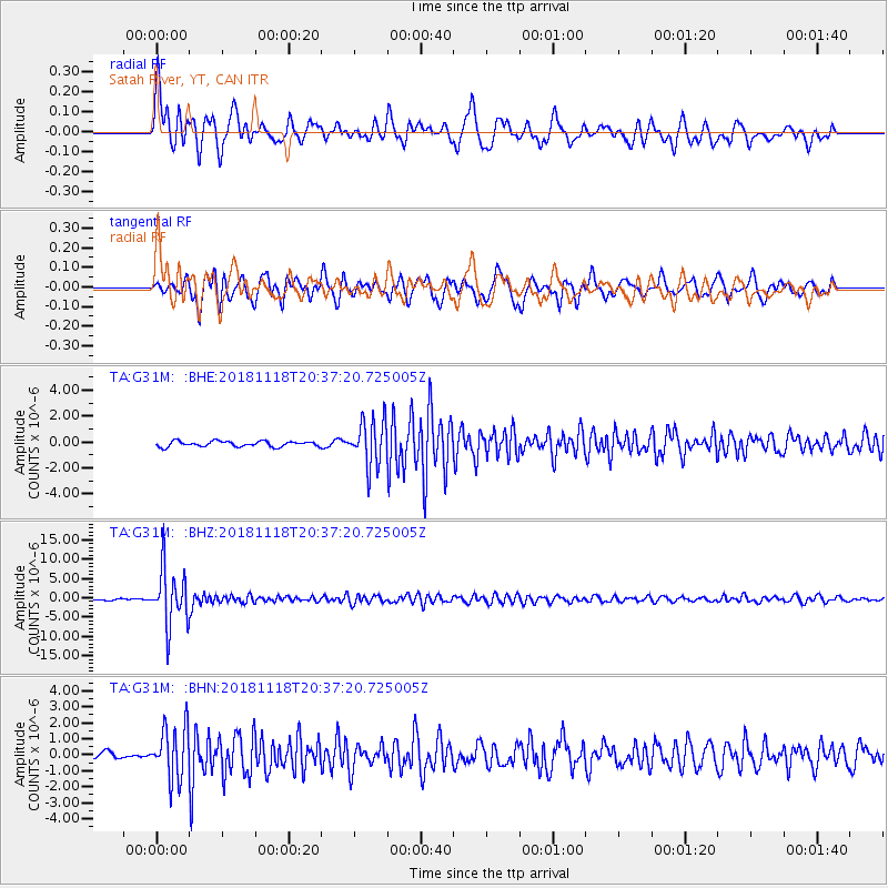
G31M Satah River, YT, CAN - Earthquake Result Viewer
*The percent match for this event was below the threshold and hence no stack was calculated.
| Earthquake location: |
Fiji Islands Region |
| Earthquake latitude/longitude: |
-17.9/-178.9 |
| Earthquake time(UTC): |
2018/11/18 (322) 20:25:45 GMT |
| Earthquake Depth: |
534 km |
| Earthquake Magnitude: |
6.7 Mww |
| Earthquake Catalog/Contributor: |
NEIC PDE/us |
|
| Network: |
TA USArray Transportable Network (new EarthScope stations) |
| Station: |
G31M Satah River, YT, CAN |
| Lat/Lon: |
66.92 N/134.27 W |
| Elevation: |
61 m |
|
| Distance: |
90.8 deg |
| Az: |
16.079 deg |
| Baz: |
221.99 deg |
| Ray Param: |
$rayparam |
*The percent match for this event was below the threshold and hence was not used in the summary stack. |
|
| Radial Match: |
79.336975 % |
| Radial Bump: |
400 |
| Transverse Match: |
75.15133 % |
| Transverse Bump: |
400 |
| SOD ConfigId: |
13570011 |
| Insert Time: |
2019-05-01 20:45:07.365 +0000 |
| GWidth: |
2.5 |
| Max Bumps: |
400 |
| Tol: |
0.001 |
|
Signal To Noise
| Channel | StoN | STA | LTA |
| TA:G31M: :BHZ:20181118T20:37:20.725005Z | 46.672684 | 7.2654757E-6 | 1.556687E-7 |
| TA:G31M: :BHN:20181118T20:37:20.725005Z | 4.5676513 | 1.6547768E-6 | 3.6228178E-7 |
| TA:G31M: :BHE:20181118T20:37:20.725005Z | 8.507006 | 1.7791522E-6 | 2.0913964E-7 |
| Arrivals |
| Ps | |
| PpPs | |
| PsPs/PpSs | |


