You are here: Home > Network List > TA - USArray Transportable Network (new EarthScope stations) Stations List
> Station H27K Steamboat Mountain, AK, USA > Earthquake Result Viewer
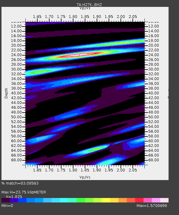
H27K Steamboat Mountain, AK, USA - Earthquake Result Viewer
| Earthquake location: |
Fiji Islands Region |
| Earthquake latitude/longitude: |
-17.9/-178.9 |
| Earthquake time(UTC): |
2018/11/18 (322) 20:25:45 GMT |
| Earthquake Depth: |
534 km |
| Earthquake Magnitude: |
6.7 Mww |
| Earthquake Catalog/Contributor: |
NEIC PDE/us |
|
| Network: |
TA USArray Transportable Network (new EarthScope stations) |
| Station: |
H27K Steamboat Mountain, AK, USA |
| Lat/Lon: |
66.23 N/141.53 W |
| Elevation: |
786 m |
|
| Distance: |
88.4 deg |
| Az: |
14.249 deg |
| Baz: |
215.325 deg |
| Ray Param: |
0.041674327 |
| Estimated Moho Depth: |
23.75 km |
| Estimated Crust Vp/Vs: |
1.83 |
| Assumed Crust Vp: |
6.577 km/s |
| Estimated Crust Vs: |
3.604 km/s |
| Estimated Crust Poisson's Ratio: |
0.29 |
|
| Radial Match: |
83.08563 % |
| Radial Bump: |
400 |
| Transverse Match: |
80.89551 % |
| Transverse Bump: |
400 |
| SOD ConfigId: |
13570011 |
| Insert Time: |
2019-05-01 20:45:16.099 +0000 |
| GWidth: |
2.5 |
| Max Bumps: |
400 |
| Tol: |
0.001 |
|

Signal To Noise
| Channel | StoN | STA | LTA |
| TA:H27K: :BHZ:20181118T20:37:09.850005Z | 27.634405 | 3.3733215E-6 | 1.2206964E-7 |
| TA:H27K: :BHN:20181118T20:37:09.850005Z | 5.90168 | 1.396446E-6 | 2.3661839E-7 |
| TA:H27K: :BHE:20181118T20:37:09.850005Z | 5.9711294 | 1.0977325E-6 | 1.8384002E-7 |
| Arrivals |
| Ps | 3.0 SECOND |
| PpPs | 10.0 SECOND |
| PsPs/PpSs | 13 SECOND |


