You are here: Home > Network List > TA - USArray Transportable Network (new EarthScope stations) Stations List
> Station S16A Weppner Ranch, Escalante, UT, USA > Earthquake Result Viewer
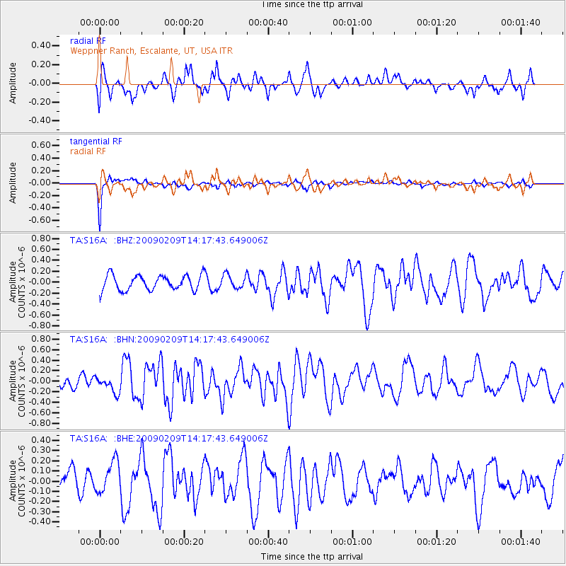
S16A Weppner Ranch, Escalante, UT, USA - Earthquake Result Viewer
*The percent match for this event was below the threshold and hence no stack was calculated.
| Earthquake location: |
Near Coast Of Northern Peru |
| Earthquake latitude/longitude: |
-6.6/-81.2 |
| Earthquake time(UTC): |
2009/02/09 (040) 14:09:02 GMT |
| Earthquake Depth: |
15 km |
| Earthquake Magnitude: |
5.5 MB, 5.5 MS, 6.0 MW, 5.9 MW |
| Earthquake Catalog/Contributor: |
WHDF/NEIC |
|
| Network: |
TA USArray Transportable Network (new EarthScope stations) |
| Station: |
S16A Weppner Ranch, Escalante, UT, USA |
| Lat/Lon: |
37.72 N/111.60 W |
| Elevation: |
1785 m |
|
| Distance: |
52.4 deg |
| Az: |
329.53 deg |
| Baz: |
140.555 deg |
| Ray Param: |
$rayparam |
*The percent match for this event was below the threshold and hence was not used in the summary stack. |
|
| Radial Match: |
61.84515 % |
| Radial Bump: |
400 |
| Transverse Match: |
90.5419 % |
| Transverse Bump: |
288 |
| SOD ConfigId: |
2658 |
| Insert Time: |
2010-03-06 18:09:24.097 +0000 |
| GWidth: |
2.5 |
| Max Bumps: |
400 |
| Tol: |
0.001 |
|
Signal To Noise
| Channel | StoN | STA | LTA |
| TA:S16A: :BHN:20090209T14:17:43.649006Z | 0.97042334 | 1.4318411E-7 | 1.4754808E-7 |
| TA:S16A: :BHE:20090209T14:17:43.649006Z | 1.3282964 | 1.6402177E-7 | 1.234828E-7 |
| TA:S16A: :BHZ:20090209T14:17:43.649006Z | 0.9479814 | 1.2987526E-7 | 1.370019E-7 |
| Arrivals |
| Ps | |
| PpPs | |
| PsPs/PpSs | |


