You are here: Home > Network List > TA - USArray Transportable Network (new EarthScope stations) Stations List
> Station I28M Miner Creek, YT, CAN > Earthquake Result Viewer
I28M Miner Creek, YT, CAN - Earthquake Result Viewer
| Earthquake location: |
Fiji Islands Region |
| Earthquake latitude/longitude: |
-17.9/-178.9 |
| Earthquake time(UTC): |
2018/11/18 (322) 20:25:45 GMT |
| Earthquake Depth: |
534 km |
| Earthquake Magnitude: |
6.7 Mww |
| Earthquake Catalog/Contributor: |
NEIC PDE/us |
|
| Network: |
TA USArray Transportable Network (new EarthScope stations) |
| Station: |
I28M Miner Creek, YT, CAN |
| Lat/Lon: |
65.45 N/139.94 W |
| Elevation: |
1188 m |
|
| Distance: |
88.2 deg |
| Az: |
15.241 deg |
| Baz: |
216.805 deg |
| Ray Param: |
0.041692056 |
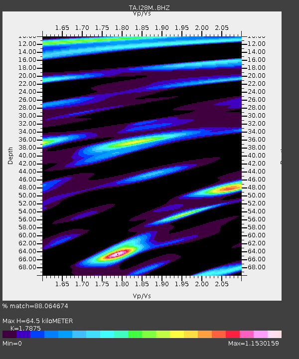
| Estimated Moho Depth: |
64.5 km |
| Estimated Crust Vp/Vs: |
1.79 |
| Assumed Crust Vp: |
6.566 km/s |
| Estimated Crust Vs: |
3.673 km/s |
| Estimated Crust Poisson's Ratio: |
0.27 |
|
| Radial Match: |
88.064674 % |
| Radial Bump: |
301 |
| Transverse Match: |
72.928856 % |
| Transverse Bump: |
400 |
| SOD ConfigId: |
13570011 |
| Insert Time: |
2019-05-01 20:45:24.052 +0000 |
| GWidth: |
2.5 |
| Max Bumps: |
400 |
| Tol: |
0.001 |
|

Signal To Noise
| Channel | StoN | STA | LTA |
| TA:I28M: :BHZ:20181118T20:37:08.69998Z | 15.651585 | 3.8030382E-6 | 2.4298103E-7 |
| TA:I28M: :BHN:20181118T20:37:08.69998Z | 6.8725157 | 1.0697388E-6 | 1.5565462E-7 |
| TA:I28M: :BHE:20181118T20:37:08.69998Z | 4.9764338 | 1.1908822E-6 | 2.3930437E-7 |
| Arrivals |
| Ps | 7.9 SECOND |
| PpPs | 27 SECOND |
| PsPs/PpSs | 35 SECOND |


