You are here: Home > Network List > TA - USArray Transportable Network (new EarthScope stations) Stations List
> Station J16K Anvik River, AK, USA > Earthquake Result Viewer
J16K Anvik River, AK, USA - Earthquake Result Viewer
| Earthquake location: |
Fiji Islands Region |
| Earthquake latitude/longitude: |
-17.9/-178.9 |
| Earthquake time(UTC): |
2018/11/18 (322) 20:25:45 GMT |
| Earthquake Depth: |
534 km |
| Earthquake Magnitude: |
6.7 Mww |
| Earthquake Catalog/Contributor: |
NEIC PDE/us |
|
| Network: |
TA USArray Transportable Network (new EarthScope stations) |
| Station: |
J16K Anvik River, AK, USA |
| Lat/Lon: |
63.28 N/160.60 W |
| Elevation: |
328 m |
|
| Distance: |
82.2 deg |
| Az: |
8.235 deg |
| Baz: |
197.564 deg |
| Ray Param: |
0.045513038 |
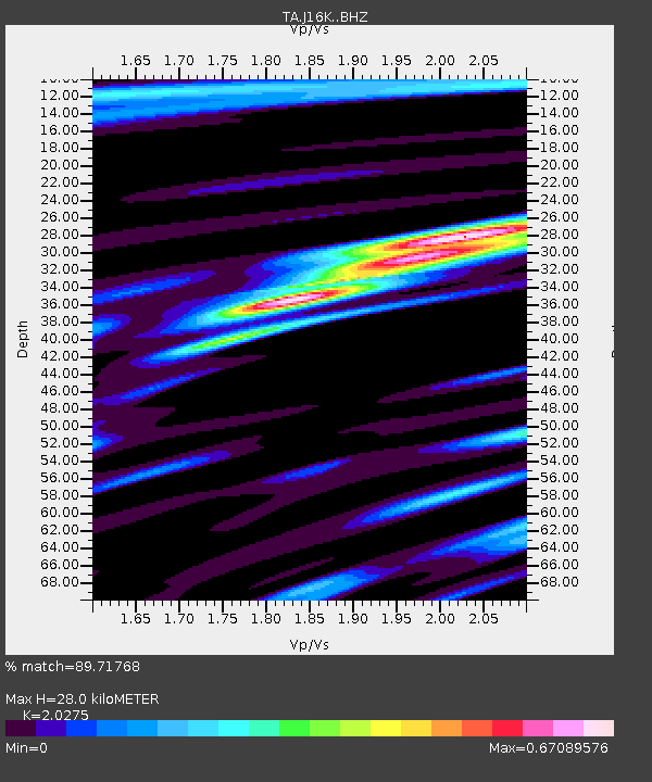
| Estimated Moho Depth: |
28.0 km |
| Estimated Crust Vp/Vs: |
2.03 |
| Assumed Crust Vp: |
6.276 km/s |
| Estimated Crust Vs: |
3.095 km/s |
| Estimated Crust Poisson's Ratio: |
0.34 |
|
| Radial Match: |
89.71768 % |
| Radial Bump: |
338 |
| Transverse Match: |
91.181114 % |
| Transverse Bump: |
400 |
| SOD ConfigId: |
13570011 |
| Insert Time: |
2019-05-01 20:45:25.728 +0000 |
| GWidth: |
2.5 |
| Max Bumps: |
400 |
| Tol: |
0.001 |
|

Signal To Noise
| Channel | StoN | STA | LTA |
| TA:J16K: :BHZ:20181118T20:36:39.750029Z | 90.03764 | 1.0386928E-5 | 1.1536206E-7 |
| TA:J16K: :BHN:20181118T20:36:39.750029Z | 23.243464 | 3.18156E-6 | 1.3687978E-7 |
| TA:J16K: :BHE:20181118T20:36:39.750029Z | 9.554027 | 1.6332893E-6 | 1.7095299E-7 |
| Arrivals |
| Ps | 4.7 SECOND |
| PpPs | 13 SECOND |
| PsPs/PpSs | 18 SECOND |


