You are here: Home > Network List > TA - USArray Transportable Network (new EarthScope stations) Stations List
> Station L19K White Mountain, AK, USA > Earthquake Result Viewer
L19K White Mountain, AK, USA - Earthquake Result Viewer
| Earthquake location: |
Fiji Islands Region |
| Earthquake latitude/longitude: |
-17.9/-178.9 |
| Earthquake time(UTC): |
2018/11/18 (322) 20:25:45 GMT |
| Earthquake Depth: |
534 km |
| Earthquake Magnitude: |
6.7 Mww |
| Earthquake Catalog/Contributor: |
NEIC PDE/us |
|
| Network: |
TA USArray Transportable Network (new EarthScope stations) |
| Station: |
L19K White Mountain, AK, USA |
| Lat/Lon: |
62.18 N/154.85 W |
| Elevation: |
650 m |
|
| Distance: |
82.1 deg |
| Az: |
11.128 deg |
| Baz: |
203.063 deg |
| Ray Param: |
0.04559342 |
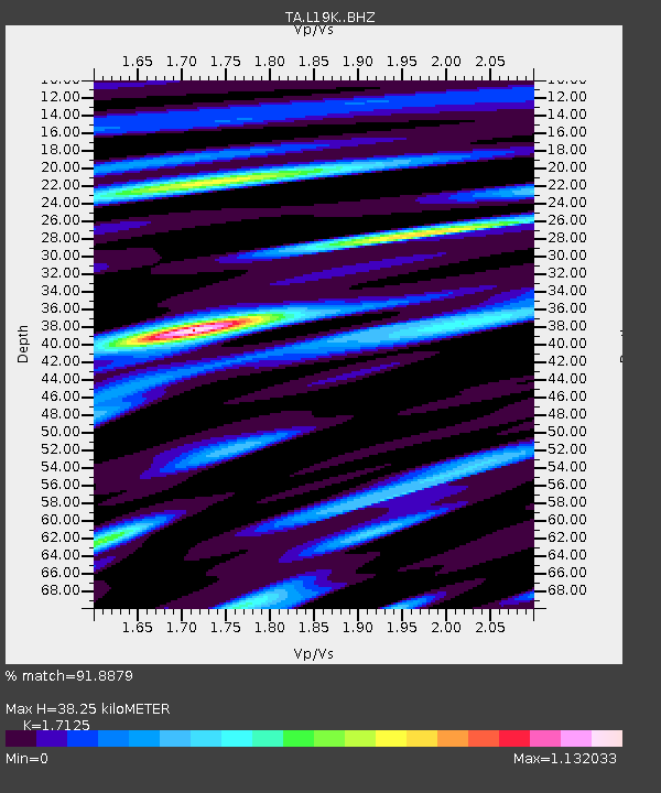
| Estimated Moho Depth: |
38.25 km |
| Estimated Crust Vp/Vs: |
1.71 |
| Assumed Crust Vp: |
6.438 km/s |
| Estimated Crust Vs: |
3.76 km/s |
| Estimated Crust Poisson's Ratio: |
0.24 |
|
| Radial Match: |
91.8879 % |
| Radial Bump: |
321 |
| Transverse Match: |
80.62028 % |
| Transverse Bump: |
400 |
| SOD ConfigId: |
13570011 |
| Insert Time: |
2019-05-01 20:45:44.053 +0000 |
| GWidth: |
2.5 |
| Max Bumps: |
400 |
| Tol: |
0.001 |
|
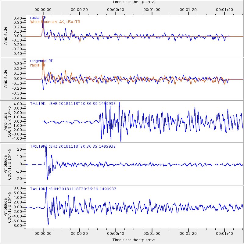
Signal To Noise
| Channel | StoN | STA | LTA |
| TA:L19K: :BHZ:20181118T20:36:39.149993Z | 79.44967 | 1.1588397E-5 | 1.4585834E-7 |
| TA:L19K: :BHN:20181118T20:36:39.149993Z | 24.79094 | 3.6769836E-6 | 1.4831966E-7 |
| TA:L19K: :BHE:20181118T20:36:39.149993Z | 9.079826 | 1.741341E-6 | 1.917813E-7 |
| Arrivals |
| Ps | 4.3 SECOND |
| PpPs | 16 SECOND |
| PsPs/PpSs | 20 SECOND |


