You are here: Home > Network List > TA - USArray Transportable Network (new EarthScope stations) Stations List
> Station P16K Nushagak River, AK, USA > Earthquake Result Viewer
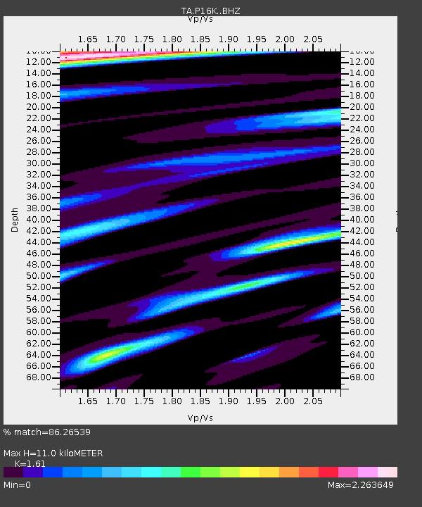
P16K Nushagak River, AK, USA - Earthquake Result Viewer
| Earthquake location: |
Fiji Islands Region |
| Earthquake latitude/longitude: |
-17.9/-178.9 |
| Earthquake time(UTC): |
2018/11/18 (322) 20:25:45 GMT |
| Earthquake Depth: |
534 km |
| Earthquake Magnitude: |
6.7 Mww |
| Earthquake Catalog/Contributor: |
NEIC PDE/us |
|
| Network: |
TA USArray Transportable Network (new EarthScope stations) |
| Station: |
P16K Nushagak River, AK, USA |
| Lat/Lon: |
59.03 N/157.99 W |
| Elevation: |
86 m |
|
| Distance: |
78.5 deg |
| Az: |
10.854 deg |
| Baz: |
200.288 deg |
| Ray Param: |
0.04795151 |
| Estimated Moho Depth: |
11.0 km |
| Estimated Crust Vp/Vs: |
1.61 |
| Assumed Crust Vp: |
6.276 km/s |
| Estimated Crust Vs: |
3.898 km/s |
| Estimated Crust Poisson's Ratio: |
0.19 |
|
| Radial Match: |
86.26539 % |
| Radial Bump: |
400 |
| Transverse Match: |
83.4495 % |
| Transverse Bump: |
400 |
| SOD ConfigId: |
13570011 |
| Insert Time: |
2019-05-01 20:46:23.346 +0000 |
| GWidth: |
2.5 |
| Max Bumps: |
400 |
| Tol: |
0.001 |
|

Signal To Noise
| Channel | StoN | STA | LTA |
| TA:P16K: :BHZ:20181118T20:36:20.975005Z | 58.683586 | 1.5539521E-5 | 2.6480183E-7 |
| TA:P16K: :BHN:20181118T20:36:20.975005Z | 9.830383 | 7.0802384E-6 | 7.202403E-7 |
| TA:P16K: :BHE:20181118T20:36:20.975005Z | 7.120228 | 4.68213E-6 | 6.575815E-7 |
| Arrivals |
| Ps | 1.1 SECOND |
| PpPs | 4.4 SECOND |
| PsPs/PpSs | 5.5 SECOND |


