You are here: Home > Network List > IW - Intermountain West Stations List
> Station MOOW Moose Ponds, Wyoming, USA > Earthquake Result Viewer
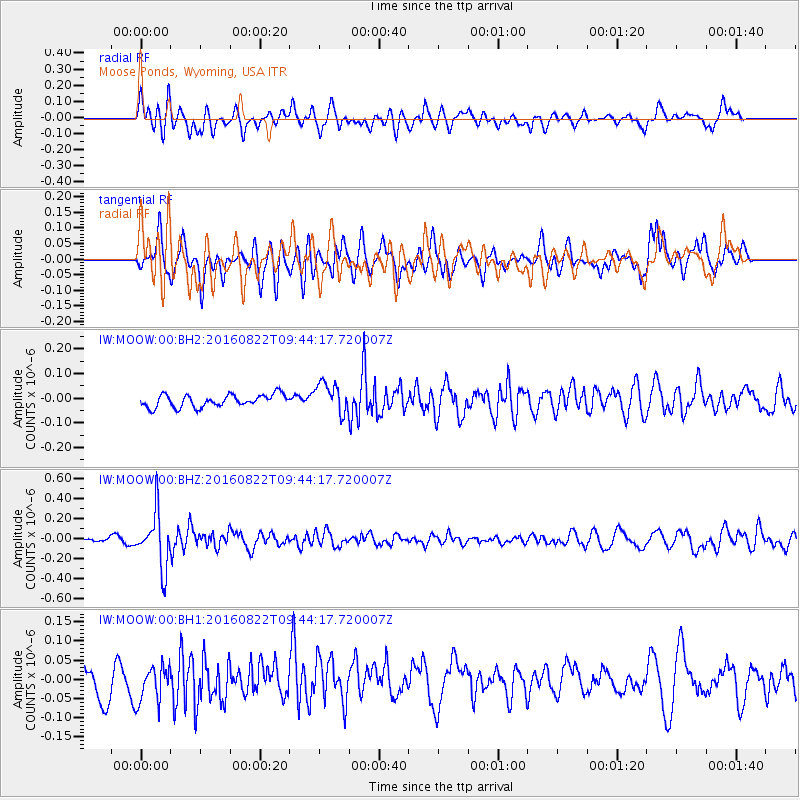
MOOW Moose Ponds, Wyoming, USA - Earthquake Result Viewer
*The percent match for this event was below the threshold and hence no stack was calculated.
| Earthquake location: |
Southeast Of Honshu, Japan |
| Earthquake latitude/longitude: |
29.9/139.1 |
| Earthquake time(UTC): |
2016/08/22 (235) 09:33:08 GMT |
| Earthquake Depth: |
404 km |
| Earthquake Magnitude: |
5.6 MB |
| Earthquake Catalog/Contributor: |
NEIC PDE/NEIC COMCAT |
|
| Network: |
IW Intermountain West |
| Station: |
MOOW Moose Ponds, Wyoming, USA |
| Lat/Lon: |
43.75 N/110.74 W |
| Elevation: |
2128 m |
|
| Distance: |
82.8 deg |
| Az: |
43.303 deg |
| Baz: |
304.732 deg |
| Ray Param: |
$rayparam |
*The percent match for this event was below the threshold and hence was not used in the summary stack. |
|
| Radial Match: |
58.323742 % |
| Radial Bump: |
400 |
| Transverse Match: |
54.347492 % |
| Transverse Bump: |
400 |
| SOD ConfigId: |
1634031 |
| Insert Time: |
2016-09-05 09:35:31.343 +0000 |
| GWidth: |
2.5 |
| Max Bumps: |
400 |
| Tol: |
0.001 |
|
Signal To Noise
| Channel | StoN | STA | LTA |
| IW:MOOW:00:BHZ:20160822T09:44:17.720007Z | 6.8647575 | 2.745347E-7 | 3.9991903E-8 |
| IW:MOOW:00:BH1:20160822T09:44:17.720007Z | 1.1978868 | 4.7635293E-8 | 3.9766107E-8 |
| IW:MOOW:00:BH2:20160822T09:44:17.720007Z | 2.4418838 | 6.164336E-8 | 2.5244184E-8 |
| Arrivals |
| Ps | |
| PpPs | |
| PsPs/PpSs | |


