You are here: Home > Network List > TA - USArray Transportable Network (new EarthScope stations) Stations List
> Station S34M Telegraph Creek, BC, CAN > Earthquake Result Viewer
S34M Telegraph Creek, BC, CAN - Earthquake Result Viewer
| Earthquake location: |
Fiji Islands Region |
| Earthquake latitude/longitude: |
-17.9/-178.9 |
| Earthquake time(UTC): |
2018/11/18 (322) 20:25:45 GMT |
| Earthquake Depth: |
534 km |
| Earthquake Magnitude: |
6.7 Mww |
| Earthquake Catalog/Contributor: |
NEIC PDE/us |
|
| Network: |
TA USArray Transportable Network (new EarthScope stations) |
| Station: |
S34M Telegraph Creek, BC, CAN |
| Lat/Lon: |
57.91 N/131.13 W |
| Elevation: |
298 m |
|
| Distance: |
85.2 deg |
| Az: |
23.366 deg |
| Baz: |
225.033 deg |
| Ray Param: |
0.04340745 |
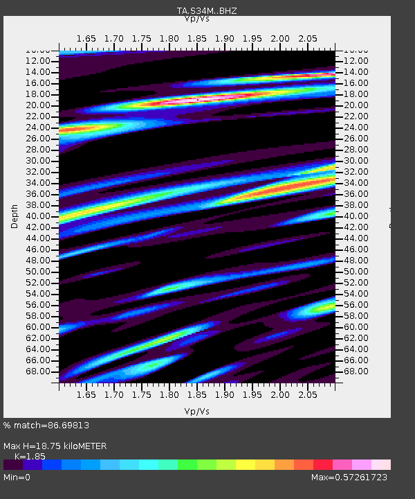
| Estimated Moho Depth: |
18.75 km |
| Estimated Crust Vp/Vs: |
1.85 |
| Assumed Crust Vp: |
6.597 km/s |
| Estimated Crust Vs: |
3.566 km/s |
| Estimated Crust Poisson's Ratio: |
0.29 |
|
| Radial Match: |
86.69813 % |
| Radial Bump: |
400 |
| Transverse Match: |
80.02009 % |
| Transverse Bump: |
400 |
| SOD ConfigId: |
13570011 |
| Insert Time: |
2019-05-01 20:46:45.667 +0000 |
| GWidth: |
2.5 |
| Max Bumps: |
400 |
| Tol: |
0.001 |
|

Signal To Noise
| Channel | StoN | STA | LTA |
| TA:S34M: :BHZ:20181118T20:36:54.82498Z | 16.888334 | 7.6867145E-6 | 4.5514938E-7 |
| TA:S34M: :BHN:20181118T20:36:54.82498Z | 7.092666 | 2.1604856E-6 | 3.046084E-7 |
| TA:S34M: :BHE:20181118T20:36:54.82498Z | 4.123058 | 2.0457594E-6 | 4.961753E-7 |
| Arrivals |
| Ps | 2.5 SECOND |
| PpPs | 7.9 SECOND |
| PsPs/PpSs | 10 SECOND |


