You are here: Home > Network List > UO - University of Oregon Regional Network Stations List
> Station WLOO Lebanon, OR, USA > Earthquake Result Viewer
WLOO Lebanon, OR, USA - Earthquake Result Viewer
| Earthquake location: |
Fiji Islands Region |
| Earthquake latitude/longitude: |
-17.9/-178.9 |
| Earthquake time(UTC): |
2018/11/18 (322) 20:25:45 GMT |
| Earthquake Depth: |
534 km |
| Earthquake Magnitude: |
6.7 Mww |
| Earthquake Catalog/Contributor: |
NEIC PDE/us |
|
| Network: |
UO University of Oregon Regional Network |
| Station: |
WLOO Lebanon, OR, USA |
| Lat/Lon: |
44.52 N/122.74 W |
| Elevation: |
284 m |
|
| Distance: |
80.5 deg |
| Az: |
37.049 deg |
| Baz: |
233.324 deg |
| Ray Param: |
0.04667389 |
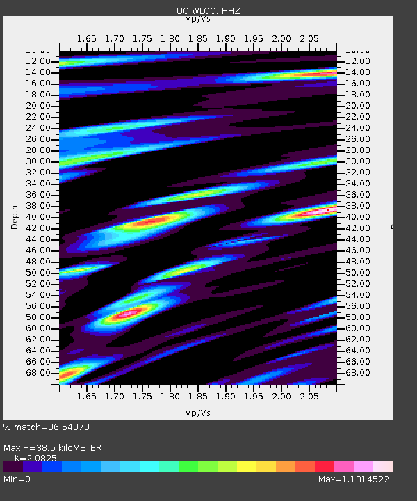
| Estimated Moho Depth: |
38.5 km |
| Estimated Crust Vp/Vs: |
2.08 |
| Assumed Crust Vp: |
6.566 km/s |
| Estimated Crust Vs: |
3.153 km/s |
| Estimated Crust Poisson's Ratio: |
0.35 |
|
| Radial Match: |
86.54378 % |
| Radial Bump: |
400 |
| Transverse Match: |
81.03071 % |
| Transverse Bump: |
400 |
| SOD ConfigId: |
13570011 |
| Insert Time: |
2019-05-01 20:47:34.538 +0000 |
| GWidth: |
2.5 |
| Max Bumps: |
400 |
| Tol: |
0.001 |
|

Signal To Noise
| Channel | StoN | STA | LTA |
| UO:WLOO: :HHZ:20181118T20:36:31.027983Z | 44.95831 | 9.84699E-6 | 2.1902491E-7 |
| UO:WLOO: :HHN:20181118T20:36:31.027983Z | 6.553435 | 2.1340873E-6 | 3.256441E-7 |
| UO:WLOO: :HHE:20181118T20:36:31.027983Z | 8.087857 | 1.6980019E-6 | 2.099446E-7 |
| Arrivals |
| Ps | 6.5 SECOND |
| PpPs | 18 SECOND |
| PsPs/PpSs | 24 SECOND |


