You are here: Home > Network List > TA - USArray Transportable Network (new EarthScope stations) Stations List
> Station E12A Beaver Dam Saddle, Pierce, ID, USA > Earthquake Result Viewer
E12A Beaver Dam Saddle, Pierce, ID, USA - Earthquake Result Viewer
| Earthquake location: |
Central Mid-Atlantic Ridge |
| Earthquake latitude/longitude: |
8.1/-38.7 |
| Earthquake time(UTC): |
2008/09/10 (254) 13:08:14 GMT |
| Earthquake Depth: |
10 km |
| Earthquake Magnitude: |
6.3 MB, 6.5 MS, 6.6 MW, 6.6 MW |
| Earthquake Catalog/Contributor: |
WHDF/NEIC |
|
| Network: |
TA USArray Transportable Network (new EarthScope stations) |
| Station: |
E12A Beaver Dam Saddle, Pierce, ID, USA |
| Lat/Lon: |
46.42 N/115.57 W |
| Elevation: |
1555 m |
|
| Distance: |
75.1 deg |
| Az: |
315.806 deg |
| Baz: |
93.908 deg |
| Ray Param: |
0.051879164 |
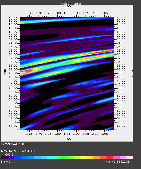
| Estimated Moho Depth: |
39.75 km |
| Estimated Crust Vp/Vs: |
1.60 |
| Assumed Crust Vp: |
6.622 km/s |
| Estimated Crust Vs: |
4.139 km/s |
| Estimated Crust Poisson's Ratio: |
0.18 |
|
| Radial Match: |
87.81002 % |
| Radial Bump: |
400 |
| Transverse Match: |
83.90495 % |
| Transverse Bump: |
400 |
| SOD ConfigId: |
2560 |
| Insert Time: |
2010-03-06 18:10:07.788 +0000 |
| GWidth: |
2.5 |
| Max Bumps: |
400 |
| Tol: |
0.001 |
|

Signal To Noise
| Channel | StoN | STA | LTA |
| TA:E12A: :BHZ:20080910T13:19:25.750027Z | 5.201364 | 4.977085E-7 | 9.568808E-8 |
| TA:E12A: :BHN:20080910T13:19:25.750027Z | 1.1012347 | 7.510227E-8 | 6.819824E-8 |
| TA:E12A: :BHE:20080910T13:19:25.750027Z | 1.8677578 | 1.483372E-7 | 7.9419934E-8 |
| Arrivals |
| Ps | 3.7 SECOND |
| PpPs | 15 SECOND |
| PsPs/PpSs | 19 SECOND |


