You are here: Home > Network List > TA - USArray Transportable Network (new EarthScope stations) Stations List
> Station E12A Beaver Dam Saddle, Pierce, ID, USA > Earthquake Result Viewer
E12A Beaver Dam Saddle, Pierce, ID, USA - Earthquake Result Viewer
| Earthquake location: |
Kermadec Islands, New Zealand |
| Earthquake latitude/longitude: |
-29.8/-177.7 |
| Earthquake time(UTC): |
2008/09/29 (273) 15:19:31 GMT |
| Earthquake Depth: |
36 km |
| Earthquake Magnitude: |
6.5 MB, 6.7 MS, 7.0 MW, 7.0 MW |
| Earthquake Catalog/Contributor: |
WHDF/NEIC |
|
| Network: |
TA USArray Transportable Network (new EarthScope stations) |
| Station: |
E12A Beaver Dam Saddle, Pierce, ID, USA |
| Lat/Lon: |
46.42 N/115.57 W |
| Elevation: |
1555 m |
|
| Distance: |
94.3 deg |
| Az: |
37.824 deg |
| Baz: |
230.423 deg |
| Ray Param: |
0.04105889 |
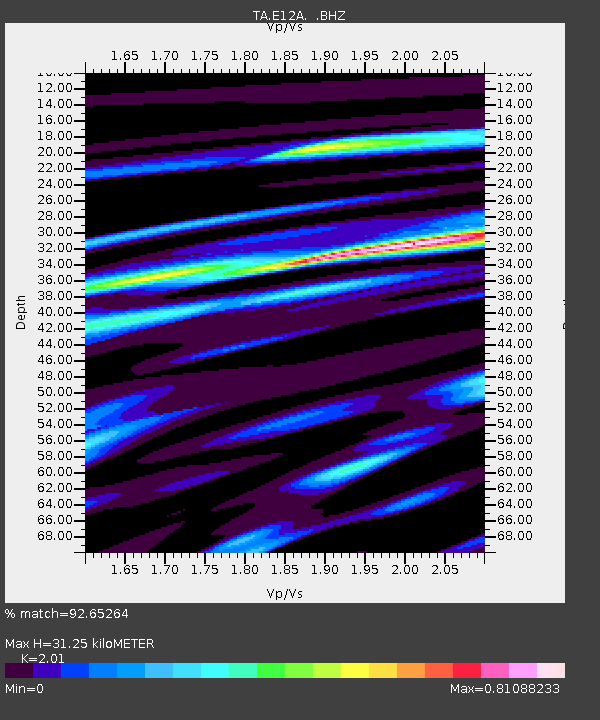
| Estimated Moho Depth: |
31.25 km |
| Estimated Crust Vp/Vs: |
2.01 |
| Assumed Crust Vp: |
6.622 km/s |
| Estimated Crust Vs: |
3.295 km/s |
| Estimated Crust Poisson's Ratio: |
0.34 |
|
| Radial Match: |
92.65264 % |
| Radial Bump: |
400 |
| Transverse Match: |
75.08695 % |
| Transverse Bump: |
400 |
| SOD ConfigId: |
2560 |
| Insert Time: |
2010-03-06 18:10:10.988 +0000 |
| GWidth: |
2.5 |
| Max Bumps: |
400 |
| Tol: |
0.001 |
|

Signal To Noise
| Channel | StoN | STA | LTA |
| TA:E12A: :BHZ:20080929T15:32:15.925022Z | 10.407124 | 5.688994E-7 | 5.4664426E-8 |
| TA:E12A: :BHN:20080929T15:32:15.925022Z | 1.9767497 | 1.4486324E-7 | 7.328355E-8 |
| TA:E12A: :BHE:20080929T15:32:15.925022Z | 3.3854613 | 1.7193919E-7 | 5.0787524E-8 |
| Arrivals |
| Ps | 4.9 SECOND |
| PpPs | 14 SECOND |
| PsPs/PpSs | 19 SECOND |


