You are here: Home > Network List > TA - USArray Transportable Network (new EarthScope stations) Stations List
> Station E12A Beaver Dam Saddle, Pierce, ID, USA > Earthquake Result Viewer
E12A Beaver Dam Saddle, Pierce, ID, USA - Earthquake Result Viewer
| Earthquake location: |
Tonga Islands Region |
| Earthquake latitude/longitude: |
-23.0/-174.7 |
| Earthquake time(UTC): |
2009/03/19 (078) 18:17:40 GMT |
| Earthquake Depth: |
34 km |
| Earthquake Magnitude: |
7.0 MB, 7.6 MS, 7.6 MW, 7.6 MW |
| Earthquake Catalog/Contributor: |
WHDF/NEIC |
|
| Network: |
TA USArray Transportable Network (new EarthScope stations) |
| Station: |
E12A Beaver Dam Saddle, Pierce, ID, USA |
| Lat/Lon: |
46.42 N/115.57 W |
| Elevation: |
1555 m |
|
| Distance: |
87.3 deg |
| Az: |
36.457 deg |
| Baz: |
232.293 deg |
| Ray Param: |
0.043348532 |
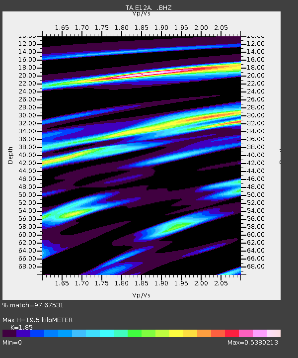
| Estimated Moho Depth: |
19.5 km |
| Estimated Crust Vp/Vs: |
1.85 |
| Assumed Crust Vp: |
6.622 km/s |
| Estimated Crust Vs: |
3.58 km/s |
| Estimated Crust Poisson's Ratio: |
0.29 |
|
| Radial Match: |
97.67531 % |
| Radial Bump: |
400 |
| Transverse Match: |
88.69045 % |
| Transverse Bump: |
400 |
| SOD ConfigId: |
2658 |
| Insert Time: |
2010-03-06 18:10:41.758 +0000 |
| GWidth: |
2.5 |
| Max Bumps: |
400 |
| Tol: |
0.001 |
|
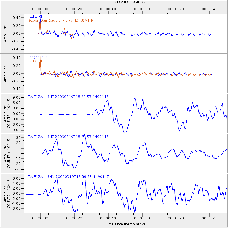
Signal To Noise
| Channel | StoN | STA | LTA |
| TA:E12A: :BHZ:20090319T18:29:53.149014Z | 13.962953 | 4.037316E-6 | 2.8914488E-7 |
| TA:E12A: :BHN:20090319T18:29:53.149014Z | 7.775007 | 8.860332E-7 | 1.1395915E-7 |
| TA:E12A: :BHE:20090319T18:29:53.149014Z | 10.322024 | 1.1752446E-6 | 1.13857965E-7 |
| Arrivals |
| Ps | 2.6 SECOND |
| PpPs | 8.2 SECOND |
| PsPs/PpSs | 11 SECOND |


