You are here: Home > Network List > TS - TERRAscope (Southern California Seismic Network) Stations List
> Station BAR Barrett Dam, California, USA > Earthquake Result Viewer
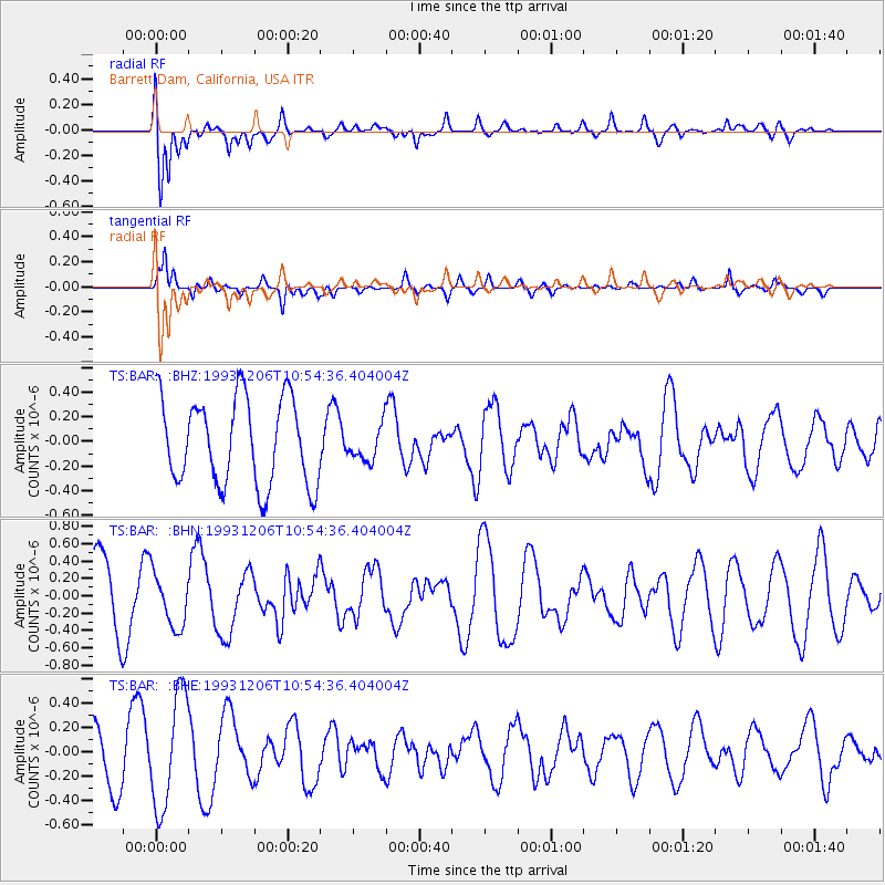
BAR Barrett Dam, California, USA - Earthquake Result Viewer
*The percent match for this event was below the threshold and hence no stack was calculated.
| Earthquake location: |
Solomon Islands |
| Earthquake latitude/longitude: |
-6.4/154.9 |
| Earthquake time(UTC): |
1993/12/06 (340) 10:42:03 GMT |
| Earthquake Depth: |
48 km |
| Earthquake Magnitude: |
5.6 MB, 5.8 MS |
| Earthquake Catalog/Contributor: |
WHDF/NEIC |
|
| Network: |
TS TERRAscope (Southern California Seismic Network) |
| Station: |
BAR Barrett Dam, California, USA |
| Lat/Lon: |
32.68 N/116.67 W |
| Elevation: |
548 m |
|
| Distance: |
92.1 deg |
| Az: |
57.517 deg |
| Baz: |
263.792 deg |
| Ray Param: |
$rayparam |
*The percent match for this event was below the threshold and hence was not used in the summary stack. |
|
| Radial Match: |
62.210735 % |
| Radial Bump: |
400 |
| Transverse Match: |
67.030785 % |
| Transverse Bump: |
400 |
| SOD ConfigId: |
4480 |
| Insert Time: |
2010-02-26 14:00:57.116 +0000 |
| GWidth: |
2.5 |
| Max Bumps: |
400 |
| Tol: |
0.001 |
|
Signal To Noise
| Channel | StoN | STA | LTA |
| TS:BAR: :BHN:19931206T10:54:36.404004Z | 0.8265133 | 3.1233128E-7 | 3.7789022E-7 |
| TS:BAR: :BHE:19931206T10:54:36.404004Z | 2.547918 | 4.6624916E-7 | 1.8299221E-7 |
| TS:BAR: :BHZ:19931206T10:54:36.404004Z | 0.3931724 | 1.3804608E-7 | 3.5110824E-7 |
| Arrivals |
| Ps | |
| PpPs | |
| PsPs/PpSs | |


