You are here: Home > Network List > TA - USArray Transportable Network (new EarthScope stations) Stations List
> Station E12A Beaver Dam Saddle, Pierce, ID, USA > Earthquake Result Viewer
E12A Beaver Dam Saddle, Pierce, ID, USA - Earthquake Result Viewer
| Earthquake location: |
Iceland |
| Earthquake latitude/longitude: |
64.0/-21.0 |
| Earthquake time(UTC): |
2008/05/29 (150) 15:46:00 GMT |
| Earthquake Depth: |
10 km |
| Earthquake Magnitude: |
6.0 MB, 6.2 MS, 6.3 MW, 6.2 MW |
| Earthquake Catalog/Contributor: |
WHDF/NEIC |
|
| Network: |
TA USArray Transportable Network (new EarthScope stations) |
| Station: |
E12A Beaver Dam Saddle, Pierce, ID, USA |
| Lat/Lon: |
46.42 N/115.57 W |
| Elevation: |
1555 m |
|
| Distance: |
51.4 deg |
| Az: |
298.055 deg |
| Baz: |
34.203 deg |
| Ray Param: |
0.06743979 |
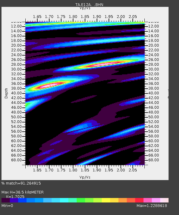
| Estimated Moho Depth: |
36.5 km |
| Estimated Crust Vp/Vs: |
1.70 |
| Assumed Crust Vp: |
6.622 km/s |
| Estimated Crust Vs: |
3.89 km/s |
| Estimated Crust Poisson's Ratio: |
0.24 |
|
| Radial Match: |
91.264915 % |
| Radial Bump: |
287 |
| Transverse Match: |
84.198395 % |
| Transverse Bump: |
398 |
| SOD ConfigId: |
2504 |
| Insert Time: |
2010-03-06 18:11:12.408 +0000 |
| GWidth: |
2.5 |
| Max Bumps: |
400 |
| Tol: |
0.001 |
|
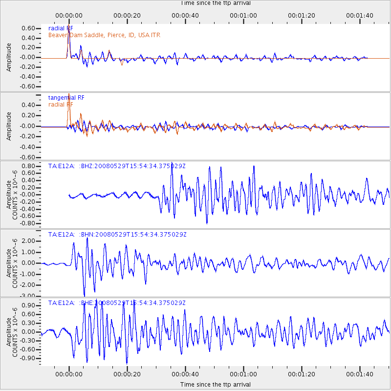
Signal To Noise
| Channel | StoN | STA | LTA |
| TA:E12A: :BHN:20080529T15:54:34.375029Z | 7.9025693 | 7.669265E-7 | 9.7047746E-8 |
| TA:E12A: :BHE:20080529T15:54:34.375029Z | 4.4661055 | 3.3445727E-7 | 7.48879E-8 |
| TA:E12A: :BHZ:20080529T15:54:34.375029Z | 4.8717237 | 2.2651605E-7 | 4.649608E-8 |
| Arrivals |
| Ps | 4.1 SECOND |
| PpPs | 14 SECOND |
| PsPs/PpSs | 18 SECOND |


